
 English
 Dutch
Dutch Japanese
 Hindi
Hindi Italian
 Spanish
 French
 German
 Chinese
 Korean
 Arabic
 Hebrew
 Russian
 Portuguese
 Danish
 Czech
Czech Polish
 Swedish
Plan Your Next
Journey to the Himalayas!
We plan custom and flexible holiday trips according to your holiday duration, extra wishes, and demands.
Plan your Trips
The Everest Base Camp Trek is an incredible adventure in the Himalayas. Trekking the foothills of Mt. Everest is every trekker’s fantasy. Hundreds of trekker flock to the region to complete this famous trek in Nepal.
If you want to trek in the Everest region, this Everest Base Camp Trek map will help you immensely along the trail. This Everest Base Camp Trek route map provides in-depth information about the trekking trails and major landmarks as well.
Furthermore, you can explore the culture, traditions, and heritage of the Sherpa community in the region. Thousands of trekkers have used this trekking map from Lukla to Everest Base Camp and completed their treks.
Moreover, the Everest Base Camp Trek map is accurate and clear. Along with the regular route, you can also learn about the possible side trips and detours for acclimatization purposes.

Short Everest Base Camp Trek 7 Days
The Everest Base Camp Trek is an incredible adventure in the Himalayas. Trekking the foothills of Mt. Everest is every trekker’s fantasy. Hundreds of trekker flock to the region to…
Besides that, you will also get to learn about the maximum altitude, total distance covered, and the time taken for the treks. You can use this Everest Base Camp Trekking map to plan your trek in advance and enjoy your trek without any hassle.
The Everest Base Camp Trek map will be your best companion along the trek. Read this Everest Base Camp Trail map carefully and start preparing for the trek. You can also book with us for a safe and exciting trip at a reasonable cost.
Our trekking journey starts after arriving at Lukla from Kathmandu on an adventurous mountain flight. The trek then passes by the settlement of Phakding to arrive at Namche Bazaar. Acclimatization at Namche is an essential process for all trekkers in the Everest region.
We resume our trek towards Tengboche and Dingboche after a day of acclimatization. The EBC trail then heads towards Lobuche and Gorakshep. After a trek of several days, you will arrive at the Short Trek To EBC. We return to Gorak Shep and hike to Kala Patthar the next morning.
For an overnight stay, we return to Periche in the evening. The following day, we descend to Namche from Pheriche on a long-duration trek. Finally, we trek back to Lukla on the final day. Our journey is complete when we fly back to Kathmandu from Lukla the next day.
Maximum altitude: Lukla (2,845 m / 9,334 ft)
Flight duration: 35 minutes
We take an early morning flight from Kathmandu to Lukla. The adventurous flight takes us to the Tenzing Hillary airport at Lukla. The scenic flight provides you with majestic views of the Himalayas.
Lukla is the entrance point of the entire Khumbu region. The Everest Base Camp trek starts in Lukla.
Maximum altitude: Lukla (2,845 m / 9,334 ft)
Time duration: 4-5 hours
Trekking distance: 14 km
We start the trekking journey from Lukla, heading towards Phakding. The trek starts by passing through the beautiful village of Chaurikharka and descending toward the Dudhkosi Ghat (2,530 m).
We observe the beautiful landscapes of the region and continue walking. Then, the trail passes alongside the banks of the pristine Dudhkosi River until we arrive at Phakding. The short trek takes about 4-5 hours.
Maximum altitude: Namche Bazar (3,440 m /11,290 ft)
Time duration: 5-6 hours
Trekking distance: 12 km
The trail passes through the alpine forests alongside the banks of Bhote Koshi. The green pastures and the unique Sherpa settlements add to the beauty of this trek. The trail crosses the pristine Bhote Koshi and proceeds into a switch-backing trail.
On our way to Namche, we can observe the beautiful mountain vista of Mt. Everest (8848m) and Lhoste (8511m). Namche is a commercial hub of the Khumbu region. You can observe Mt. Thamserku (6648m), Kwangde RI (6224m), and Mt. Khumbila (5707m).
The total time taken to cover the trekking distance is around six hours. Trekkers rest and acclimate at Namche Bazaar for a day or two, and they can also plan further using the Everest base camps map.
Maximum altitude: Tengboche (3,870 m / 12,700 ft)
Time duration: 5-6 hours
Trekking distance: 10 km
After acclimatizing at Namche, we resume the trek and head towards Tengboche. Tengboche (3870m) is the spiritual hub of the Khumbu region. The Everest Tengboche Buddhist Monastery Trek is one of the oldest monasteries in the area.
The spiritual monastery is an essential landmark in the region. Musical chants and prayers conducted in the monastery will liven up your spirits. Besides that, you will also get incredible mountain views of Everest, Ama Dablam, Tawachee, Nuptse, Lhotse, Kwangde, Kantega, Thamserku, and others.
Maximum altitude: Dingboche (4,410 m / 14,470 ft)
Time duration: 4-5 hours
Trekking distance: 10.8 km
The trail today starts from Tengboche and heads towards Dingboche. The trail is a smooth uphill ascent from Tengboche. Dingboche has a barren landscape with no vegetation. The desert-like terrain provides a unique change of scenery for the trekkers. Trekkers generally acclimate at Dingboche for the second time on the trek.

VIP Everest Base Camp Trek for Beginners
The Everest Base Camp Trek is an incredible adventure in the Himalayas. Trekking the foothills of Mt. Everest is every trekker’s fantasy. Hundreds of trekker flock to the region to…
Maximum altitude: Lobuche (4,940 m / 16,210 ft)
Time duration: 6-7 hours
Trekking distance: 11 Km
The trek from Dingboche starts on rough terrain. There are two alternatives to arriving at Lobuche. The journey takes us through 2 hours of the steep climb until you arrive at Dukla. From Dukla, you will walk straight uphill to arrive at the memorial shrines of Scott Fischer and Rob Hall.
These mountaineers lost their lives on the expedition to Mt. Everest. After a trek of around 45 minutes, you will arrive at a junction. We take the eastern path, leaving the western path to Dzongla behind as per our Everest Base camps map. Finally, we will arrive at Lobuche and stay overnight.
Maximum altitude: Everest Base Camp (5,363 m/ 17,595 ft)
Time duration: 7-8 hours
Trekking distance: 15 Km
This section of the trek is quite long. After trekking on a smooth and easy path for some distance, the trail turns into a steep uphill climb. We climb for about 2 hours to arrive at the frozen sand bed of Gorak Shep.
We take an up-and-down trek from Gorak Shep to the spectacular Everest Base Camp. This section of the trek is on a rough gravel top and, thus, requires caution while walking.
The 360-degree panoramic view of the majestic mountains will overwhelm you. You can take incredible photographs and explore the base camp area. We will then return to Gorak Shep in the evening to stay overnight.
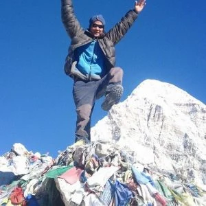
Maximum altitude: Kala Patthar (5,545 m/ 18,192 ft)
Time duration: 6-7 hours
Trekking distance: 18 km
The trail moves in the Northwest direction from Gorakshep. Kala Patthar is the highest point of the trek and lies towards the west of Everest Base Camp. The high-altitude destination is also the toughest climb section of the entire trek.
After waking up early, we start our trek for Kala Patthar. It will take us around 2 hours for the ascent over the mountains to arrive at Kala Patthar. You will get incredible mountain views from Kala Patthar. Some of the most beautiful pictures of Mt. Everest are from the Kalapathar viewpoint.
After taking some incredible pictures of this place, we head back to Gorak Shep. We will arrive at Gorakshep after a trek of almost 45 minutes. The trail then heads south until we arrive at a junction.
The trail leading to Pheriche is shorter and different than the trail to Dingboche and Lobuche. After a trek of a few hours, we arrive at Periche where we stay overnight.
Maximum altitude: Pheriche (4,280 m/ 14,041 ft)
Time duration: 5-6 hours
Trekking distance: 14.3 km
The trail from Periche to Khumjung village starts on a gentle note. You will be walking the same route as before but will find a different perspective of the region. You need to walk through the beautiful pine forests to arrive at Tengboche. The beautiful valleys and landscapes will enthrall you.
We observe the florals and fauna of the region and arrive at the junction of Sansa. Then we cross the Sansa junction to arrive at Khumjung village. The beautiful view of the snow-capped mountains from the village will enchant you. We continue the uphill trek till we arrive at Namche. We will rest overnight at Namche.
Maximum altitude: Namche Bazar (3,440 m /11,290 ft)
Trek duration: 5-6 hours
Trek distance: 13.5 km
The trek from Namche moves along an easy trail. You can observe the pristine waterfalls along the trail as well. After passing by the traditional Buddhist monasteries and a few suspension bridges, we will arrive at Monjo.
We will have our lunch at Monjo. We then resume our trek towards Lukla passing through Phakding. The trail then leads us to Lukla after a trek of a few hours as our trekking journey comes to an end. We will stay overnight at Lukla.
Maximum altitude: Lukla (2,845 m / 9,334 ft)
Flight duration: 35 minutes
We take a scenic mountain flight from Lukla to Kathmandu. We can observe the aerial view of the beautiful mountain vista for one last time.
From the year 2021 Lukla to Kathmandu or Kathmandu to Lukla flight in high trekking season time is from Ramhechap Manthali airport. Ramechp airport is 180Km far from Kathmandu it will take 3 to 5 hours to drive in a private jeep or in a car.
The Everest Base Camp Trek map is an essential piece of information during your trek. This information will come in handy at all times and is a must-have for all trekkers.
Furthermore, you will also get to know about the maximum altitude, total distance covered, and the time duration of the trek. Some of the reasons that make the trek to Everest Base Camp map essential are as follows:
The Everest Base Camp trek map is the best companion for solo trekkers. Solo travelers can use this map to find the right path during their trek.
Trekkers can also stay away from the restricted paths along the Everest Base Camp Trek. This way trekkers can travel safely without any hassle.
Everest base camp trek online map for download for your mobile please visit the Great Himalayan trails shop ( GHT) and get the best EBC online maps for your mobile phone.

The Everest Base Camp Trek is an incredible adventure in the Himalayas. Trekking the foothills of Mt. Everest is every trekker’s fantasy. Hundreds of trekker flock to the region to…
The Everest Base Camp trek map provides essential trek details. You can estimate the arrival time at your destination and thus schedule your trek accordingly. The Everest Base Camp trek map helps you plan your trip in advance.
Moreover, you will have an overall perspective of the region and day-to-day destination during the trek. Besides that, this Everest Base Camp trek detailed map also provides you with important details like maximum altitude, distance covered, and trek duration along the trek.
The Everest Base Camp trek map also helps you take side trips and detours during the trek. You can explore the mountain regions during the acclimatization period. Moreover, this map of a trek from Lukla to Everest Base Camp will guide you through the lesser-known routes for an incredible adventure.
The Everest Base Camp trek map provides accurate details of the major landmarks along the trails. This valuable piece of information will help you guide the difficult terrains of the Everest region with ease.
The map of the trek from Lukla to Everest Base Camp is also available in pdf format. The Everest Base Camp Trek map pdf version is for those tech-savvy trekkers who do not want to carry a piece of paper.
You can estimate the total time taken for the trip and thus plan the schedule in advance. Furthermore, you can also calculate the maximum altitude, time duration of the trek, and the total distance covered from the map. Overall, the Everest Base Camp Trek map is an essential piece of information that will help you immensely along the trek.
Contact us for detailed information about the packages.


We plan custom and flexible holiday trips according to your holiday duration, extra wishes, and demands.
Plan your Trips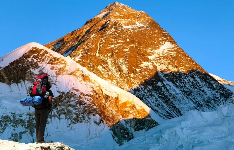
Chat with our Travel Designer Shiba
Need assistance? Our expert agent is here to help! Please fill out the form below to initiate a chat and get your queries resolved quickly.