
 English
 Dutch
Dutch Japanese
 Hindi
Hindi Italian
 Spanish
 French
 German
 Chinese
 Korean
 Arabic
 Hebrew
 Russian
 Portuguese
 Danish
 Czech
Czech Polish
 Swedish
 View the Trip Map
 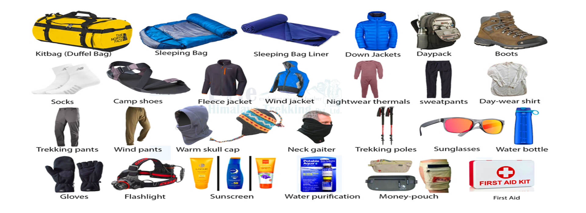 Equipment Checklist
 Plan Your Next
Journey to the Himalayas!
We plan custom and flexible holiday trips according to your holiday duration, extra wishes, and demands.
Plan your Trips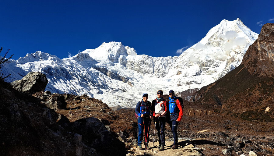


Max. Altitude
5160m
Best Season
Sep -Dec & Mar-JuneActivity
Trekking
Start / End Point
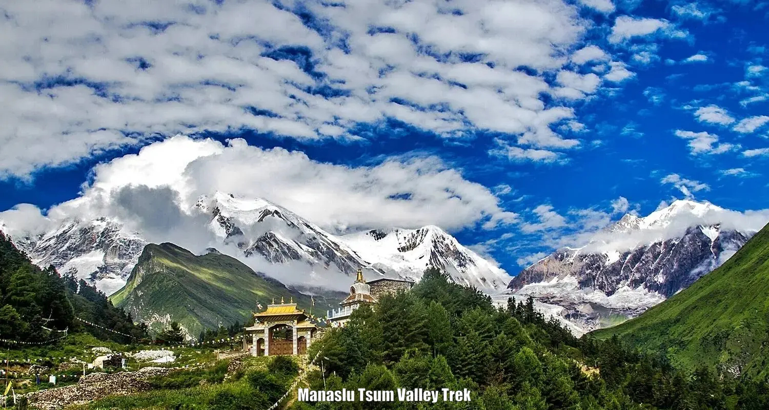
Kathmandu/KathmanduThe Manaslu Larkya Pass Trek is one of the newly introduced challenging and adventurous treks in Nepal’s Manaslu area. It is located midway between Langtang and Annapurna in the west-northwest of Nepal. In the native language, the name Manaslu refers to the friendly and powerful deity which means “The Spirit-Mountain”.
The eighth-highest peak in the world, Mountain Manaslu is situated in Nepal’s Gorkha district in the northern Himalayan range. Trekking permission for this area was specially issued to the trekkers by the Nepali government evidently in 1992. Undoubtedly, trekking in the Manaslu zone offers an intense and thrilling experience.
Accordingly, it offers breathtaking vistas of the spectacular snow-capped mountains that abound with the childlike innocence of the locals.
Visitors can experience a genuine adventure thanks to the unmatched beauty of Manaslu and its unique fusion of Tibetan and Nepalese culture. The mountains and valleys are covered with a variety of natural habitats here.
Since the Manaslu region is one of Nepal’s most isolated areas, there has been minimal to nonexistent activity in certain areas. Perhaps as a result of the area’s isolation, the beauty of the environment has not been altered and is still striking, lovely, and hypnotic.
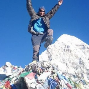
The highest viewpoint on this journey is Manaslu Laryka-La Pass, at 5,160 meters. The Manaslu Circuit trek is thought to be among the hardest in Nepal.
Luxury lodge trekking in the Manaslu circuit getting popular we are providing hot showers, comfortable private rooms, and food unlimited choices for menu the local guide with a government-licensed holder & fluent English, French, and German-speaking with great information.
Therefore the region demands a strong trekking background and excellent physical fitness. the local porter is helpful and they will carry the trekking gear from the Manaslu circuit trek.
Trekking the Larkya Pass will reward the daring with an unmatched alpine experience. Difficult ascent and occasionally slick passes require caution. However, the trail is well-traveled, and the descent is not very challenging. In general, only a small number of trekkers travel to the Manaslu Larkya Pass Trek.
If you want to explore details best local company for Manaslu circuit trek is Life Himalaya trekking offers the best local guide with a high-altitude friendly itinerary for the Manaslu circuit trek for 14 days including luxury lodges and private transportation.
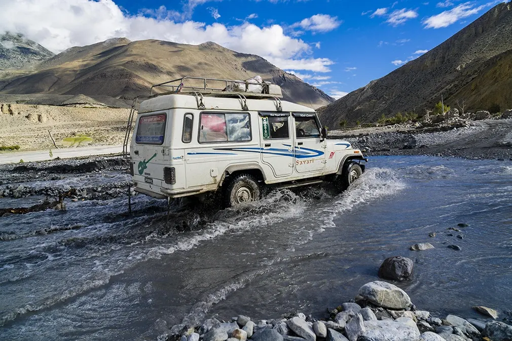
From Kathmandu, you may start your journey to the Manaslu Circuit. Starting at 6 and 8 in the morning, you may catch a direct private 4*4 jeep from Kathmandu’s hotel to Machh Khola via Arughat.
You may see the amazing vistas, terraces, and lush slopes of Annapurna, Manaslu, Ganesh Himal, and Langtang Himal as you pass the crest of the Kathmandu Valley. Depending on your schedule and preference, you can go to Arughat through the Gorkha Bazaar or Dhading Besi. However, we shall pass via Dhadingbesi on our trip.
The road has been extended from the Arughat Bazaar to the Sotikhola (12.9 km) and to the Machhakhola (13 km), which may be reached by Jeep 4*4 vehicle straightaway. A dirt road is passable in 2 1/2 to 3 hours. The route will approach the Budhigandaki River’s bank.
We get to see beautiful vistas of Shringri Himal and how the villagers live along the road. Driving from Sotikhola to Machhakhola (Fish River) further examines people’s daily lives as it passes past rice fields. We spend the night in the village of Machhakhola.
Maximum Altitude
870 m.Meals
Breakfast, Lunch and DinnerTrek Duration
8 hours DriveAccomodations
LodgeOn this day, the route will pass via Tatopani, Duman, Dovan, and Thado Bhanjyang as it travels from Machha Khola to Jagat. The riverside path is continued.
The route travels through Tharo Khola, Khorlabesi, and ultimately arrives at Tatopani, a hot spring, by way of brief ascents and descents. After eating lunch and taking a hot bath in Tatopani, we will accordingly hike up and down ravines and between carved trees.
We arrive at Dovan after navigating a mountain and the Budhi Gandaki River. As we ascend, the vista and the plants change, bringing us closer to Jagat. During the trek through the jungle, Langur monkeys could appear unexpectedly. Stay the night at the sizable Gurung village of Jagat.
Maximum Altitude
1,340 m.Meals
Breakfast, Lunch and DinnerTrek Duration
7 hours walkAccomodations
LodgeFollowing the Budhi Gandaki River’s uphill course, you will start the day by trekking via the villages of Salleri and Sirdibas. Then we pass through the Gurung settlement of Philim after passing via Ghatta Khola. We walk past farms where maize, millet, potatoes, and vegetables are grown before reaching Nupri.
You will eventually reach the Gurung hamlet of Deng after across a few more suspension bridges, strolling through bamboo forests, and passing the Nyak settlement. You will spend the night here and enjoy a breathtaking view of Shringi Himal (7161m).

Maximum Altitude
1,860 m.Meals
Breakfast, Lunch and DinnerTrek Duration
7 hours walkAccomodations
LodgeWe hike to Prok from Deng. This settlement is perched on a ridge and is located at an elevation of 2,397 meters. The Bhotias, an indigenous mountain population who are more culturally similar to Tibetan Buddhists than to Nepalese Hindus, live in the village of Prok, which is rarely visited by outsiders.
As we travel into the canyon, we ascend and descend several times while taking in the breathtaking vistas. We cross the big Buri Gandaki twice.
Maximum Altitude
2,397 m.Meals
Breakfast, Lunch and DinnerTrek Duration
6 hours walkAccomodations
LodgeThe lovely Prok Village is taking today off. The city of Prok is located on a level area directly above the Budhigandaki River. Meanwhile, this is the place to go if you want to experience authentic Nepalese culture and a true village.
You will visit Kal Tal/Kal Chhumar Lake (3,574m) throughout the day to enjoy the breathtaking panoramic views and the serenity of Kal Lake. Go back to Prok to spend the night.

Maximum Altitude
2,397 m.Meals
Breakfast, Lunch and DinnerTrek Duration
6 hours walkAccomodations
LodgeYou start the day’s hike by traveling to Ghap on a downward path. Wander through a lush forest with pine and coniferous trees. Be sure to jump two crossings before ascending to Namrung. From there, follow the road to Barcham, a community with gently undulating green fields.
You reach the sizable settlement of Lho especially after climbing a hill from there. It has a monastery, and Lho is a large community. Hence, we’ll have an opportunity to learn about the Tibetan way of life and see the neighborhood monastery there. Overnight, we spend at Lho village.
Maximum Altitude
3,180 m.Meals
Breakfast, Lunch and DinnerTrek Duration
6 hours walkAccomodations
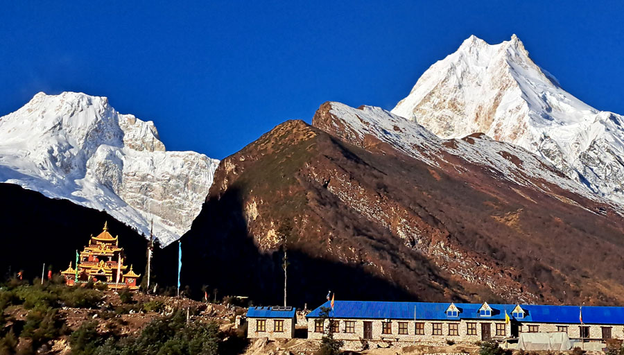
LodgeMove away from Lho village and toward Sama Gaon. Pass a woodland on your way to Shyala, then ascend gradually. You must go about an hour on foot from Shyala to Sama Gaun. Mountain vistas diminish as you approach the village, but the yak pastures and conventional villages will draw you in.
Spend the afternoon hiking up to the historic Gomba hamlet above the town and exploring the intriguing Sama Gaon village’s walkways. The town is home to one of the Nubri Valley’s oldest monasteries. Spend the night at Sama Gaon.
Maximum Altitude
3,520 m.Meals
Breakfast, Lunch and DinnerTrek Duration
6 hours walkAccomodations
LodgeSama Gaon’s acclimatization day is today to avoid altitude sickness. In addition, you’ll do a climb to Pungyen Gompa in the Nubri Valley’s east as acclimatization. It will take roughly two and a half hours to walk the ridge to Pungyen Monastery. You can pack a lunch to eat at the rest spots while on this acclimatization walk.
Another option is to hike towards Manaslu Base Camp for 3 to 4 Hours, where we’ll have stunning views of the Birendra Lake (45-minute walk), glacier, and valley. Return to Samagaun for an overnight stay.

Maximum Altitude
3,520 m.Meals
Breakfast, Lunch and DinnerTrek Duration
6 hours walkAccomodations
LodgeAfter breakfast, the walk takes us to a spectacular alpine landscape where blue sheep can be seen grazing on the neighboring desolate hills. To go to the pine and birch forests, we accordingly]cross the suspension bridge. Moving forward, we will eventually pass another bridge and ascend to the opposite side of the Budhi Gandaki River.
You may have a pleasant walk among the local alpine plants because the route is more broad and easy today than it is on other days. As you ascend to the town of Samdo, pass through imposing Mani walls that are adorned with prayer flags and encrypted with cryptic prayers. Spend the night at Samdo.
Maximum Altitude
3,875 m.Meals
Breakfast, Lunch and DinnerTrek Duration
6 hours walkAccomodations
LodgeAfter breakfast today, we climb for three to four hours to the Tibet border at Ruila Pass (4,998m). Enjoy the Tibetan border while snapping photographs before returning to for the night.

Maximum Altitude
4,998 m.Meals
Breakfast, Lunch and DinnerTrek Duration
6 hours walkAccomodations
LodgeThe trek takes us across a bridge, up through the Larkya bazaar’s market streets, and along the ancient trade route to Tibet. The route arrives at Dharamsala, also known as Larkya Phedi, after passing past several Mani walls and stone cottages and walking through the Syacha Glacier’s gorge.
You halt in Dharamsala, a little town with few residences. Get a good night’s rest since tomorrow you will cross the Larkya La, the highest point of your walk and a difficult mountain pass. Overnight in Dharamsala.
Maximum Altitude
4,460 m.Meals
Breakfast, Lunch and DinnerTrek Duration
6 hours walkAccomodations
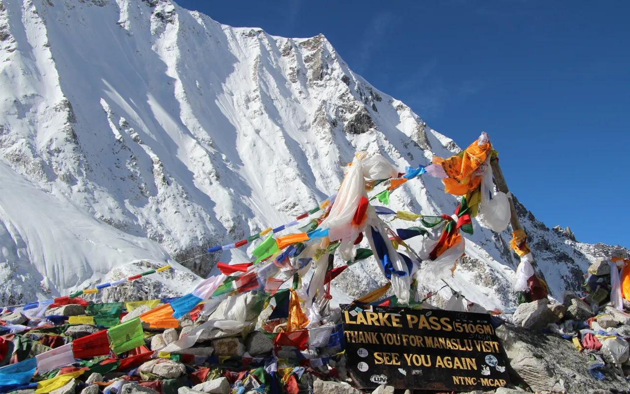
LodgeGiven that the day is going to be difficult, you set off on your walk early in the morning. The ascent is challenging since the path passes through the rock layers of Larkya Glacier. You must keep ascending the cold, rugged route until you reach Larkya La Pass.
From the pass, a beautiful vista of many mountains is seen eventually. Although the steep fall from here is difficult, the experience is equally gratifying. Bimthang anticipates the end of a challenging day. Spend the night in Bimthang.
Maximum Altitude
5,160 m.Meals
Breakfast, Lunch and DinnerTrek Duration
8 hours walkAccomodations
LodgeThe last day of the trek around Manaslu is today. You will significantly stroll through verdant woodlands teeming with wildlife and plants. You leave behind the majestic Himalayas shortly as you descend to Dharapani from Bimthang. To get to Gho, the path drops to Dudh Khola and travels through extensive pine and rhododendron forests.
A portion of Lamjung Mountain, which towers above the Marshyangdi valley, may be seen from the bottom of the valley. Accordingly, we reach Dharapani, the major path of the Annapurna Circuit trek, after passing through the villages of Tilje and Thonje. We’ll spend the night at Dharapani.
Maximum Altitude
1,963 m.Meals
Breakfast, Lunch and DinnerTrek Duration
7 hours walkAccomodations
LodgeFrom Dharapani to Beshisahar, a shared Jeep will transport you. Finally, you’ll board a public bus at Besisahar to get to Kathmandu.
Maximum Altitude
1,340 m.Meals
Breakfast and LunchTrek Duration
9 hours driveTips and Donations to Monasteries and Porters.
The higher elevation hike to Manaslu base camp is in the Himalayas. All seasons are suitable for Manaslu Circuit trekking. However, because of the temperate temperature and steady environment that these seasons offer, spring and fall are the finest periods to hike Manaslu.
It will thus be challenging to even hike the Short Manaslu circuit trek during the winter or monsoon seasons. These are the best times to go hiking and take in unimpeded vistas of the mountains because the weather is dry and clear.
The nights are cool, and the days are bright. The trails do get packed and crowded during these peak seasons, though.
You require three different permissions for the Manaslu trip because it is a restricted area trek in Nepal. A local agency may be able to issue the special restricted area permit that you want. For the hike, you will also require an MCAP and ACAP permit.
A permit for the Manaslu Restricted Area must be obtained from the Department of Immigration. All of these permits are available at the Nepal Tourism Board’s offices in Pokhara and Kathmandu.
• Entry Permit for the Manaslu Conservation Area Project (ACAP) costs NRS 3000 for foreigners, NRS 1000 for residents of SAARC nations, and NRS 100 for Nepalese.
• Entry Permit for the Annapurna Conservation Area Project (ACAP): NRS 3000 for foreigners, NRS 1000 for residents of SAARC nations, and NRS 100 for Nepalese.
• Manaslu Restricted Area Permit:(a) From September to November: $100 per person for 7 days; after the seventh day, $15.00; (b) From December to August: $75 per person for 7 days; after the seventh day, $10.00.
• NRS 1000 TIMS Card. NRS 300 for nationals of SAARC nations.
$1,400
per person (in USD)
top rated - Based on 200 TripAdvisor & 93 Google Reviews
Join us on similar trips in the same region

We plan custom and flexible holiday trips according to your holiday duration, extra wishes, and demands.
Plan your Trips
Chat with our Travel Designer Shiba
Need assistance? Our expert agent is here to help! Please fill out the form below to initiate a chat and get your queries resolved quickly.