

 English
 Dutch
Dutch Japanese
 Hindi
Hindi Italian
 Spanish
 French
 German
 Chinese
 Korean
 Arabic
 Hebrew
 Russian
 Portuguese
 Danish
 Czech
Czech Polish
 Swedish




Plan Your Next
Journey to the Himalayas!
We plan custom and flexible holiday trips according to your holiday duration, extra wishes, and demands.
Plan your Trips


Max. Altitude
5106 m
Best Season
Mar-May, Sep-Nov
Activity
Trekking
Start / End Point
Kathmandu/KathmanduThe Manaslu Larke Pass Trek is a 23-day Himalayan adventure in western Nepal. It is Nepal’s best remote circuit treks, taking you all the way around Mount Manaslu (8,163m), the eighth-highest mountain in the world.
The trip also involves crossing the renowned Larkya La Pass (about 5,106m), one of the picturesque high passes in Nepal. During the trek, you have expansive mountain scenery, serene paths, and a village lifestyle.
This adventure starts by taking a scenic drive between Kathmandu and Gorkha. This is where the journey goes along the valley of the Budhi Gandaki River.
The path cuts across terraced agricultural lands, wood-filled forests, deep ravines, and isolated villages that have not changed over the centuries. It takes you through Gurung, Tamang, and Tibetan-influenced (Nubri) villages and Buddhist monasteries, mani walls, prayer flagged paths, which are very high in Tibetan-influenced culture.
The landscape gradually varies with the altitude. Hot lower valleys become mountainous forests and clear mountainous landscapes. A visit to the natural hot springs in Tatopani is one of the restful experiences of the trek, as you can relax your muscles after a day of long walks.
One of the important acclimatization points is Sama Gaon at 3500 meters. This is where you take an additional day to relax and acclimatize to the height. Proposed side trips to Manaslu Base Camp, 4880m, and the scenic Birendra Lake complement the experience and aid in safe altitude adjustment.
The most challenging and rewarding day of the Manaslu Larke Pass Trek is the crossing of Larkya La Pass. You begin in the morning and walk slowly to the summit of the pass.
Up on the top, you can enjoy broad panoramas of snow-capped mountains, glaciers, and mountain valleys. The trail crosses the pass, and as well, the scenery and climate change as the trail leads to the region of Annapurna.
The trek covers roughly 160 to 180 kilometers in total, depending on the start and end points and side trips. The average number of hours to walk per day is between 5 and 7 hours, depending on the terrain and altitude.
You will be staying in simple and comfortable teahouses on the way, where you will have warm meals and local hospitality. This journey is a challenge in itself, but very fulfilling. It offers a perfect balance of nature, culture, and adventure, making the Manaslu Larke Pass Trek a memorable Himalayan journey for experienced trekkers.
You will reach Kathmandu, the capital city of Nepal, which is at 1400 meters. Once you finish the airport formalities, our company staff will pick you up and take you to the hotel. The remaining day is left to take a rest or make a short stroll around Thamel to visit local stores and cafes.
In the evening, you will meet our guide for a short briefing about the Manaslu Larke Pass Trek and check your gear. You will stay in a comfortable hotel overnight.
Maximum Altitude
1,400 m.Trek Duration
Airport to Hotel Transfer
Accomodations
HotelToday we will go sightseeing in Kathmandu and get ready for the trek. We will explore key cultural sites like Kathmandu Durbar Square or Swayambhunath after breakfast. Through such visits, we are able to learn about local history and traditions.
In the meantime, our guide will take care of permits and paperwork. We will have time later to purchase any last-minute trekking stuff in Thamel.
Later in the afternoon, we will have a final briefing on the trek. You can have a Nepali dinner and rest in the evening for tomorrow’s trek.

Maximum Altitude
1,400 m.
Meals
BreakfastTrek Duration
Full day tourAccomodations
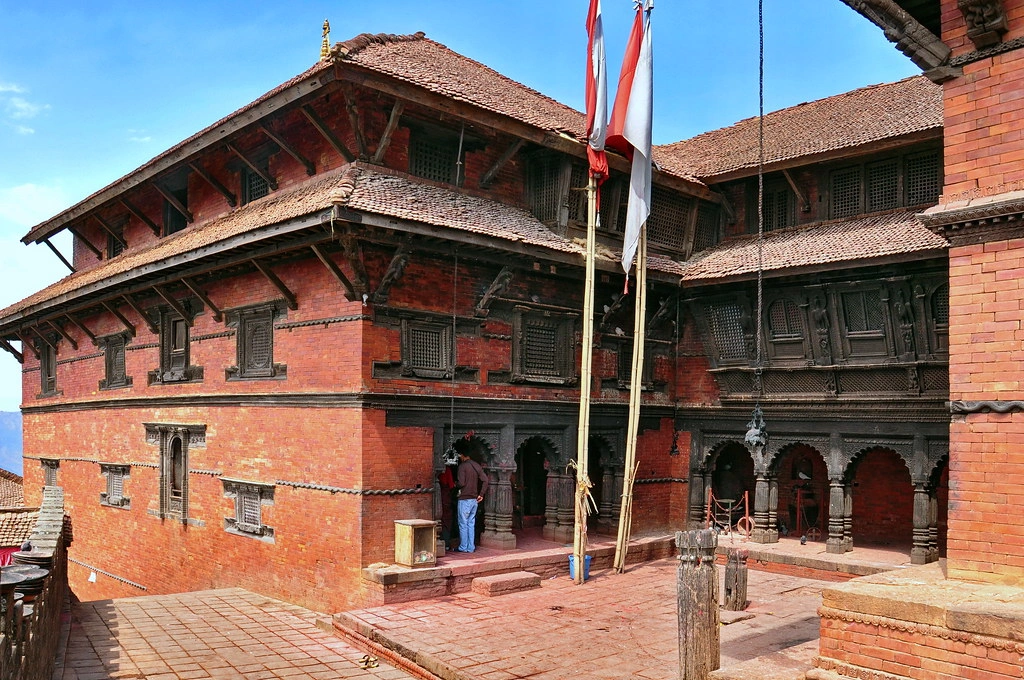
HotelWe will begin early and make a journey from Kathmandu to Gorkha, which will take approximately 6 to 7 hours. The drive provides picturesque scenery of rivers, hills, forests, and villages.
In the process, we might make optional stops at Kurintar to take a ride on a cable car to Manakamana Temple. We will arrive at Gorkha by afternoon and stay in a local teahouse.
Depending on the time, we can explore the old Gorkha Palace. We will stay overnight and have a warm dinner in Gorkha.
Maximum Altitude
1,150 m.Meals
Breakfast, Lunch, DinnerTrek Duration
6-7 hours DriveAccomodations
HotelToday we will start walking across terraced fields, orchards, and small villages. The path is generally easy and consists of local footpaths.
In the process, we will observe the traditional countryside life and agricultural land. We will arrive at Khanchowk, a Gurung village, on a ridge above the valley, by midday.
The scenery in this way is beautiful and serene. During the afternoon, we will unwind in one of the family-owned teahouses and have a warm Nepali dinner.
Maximum Altitude
1,000 m.Meals
Breakfast, Lunch, DinnerTrek Duration
6-7 hours TrekAccomodations
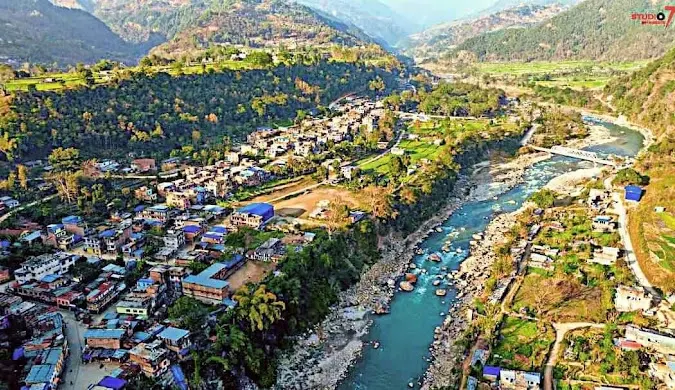
TeahouseIn the morning, after breakfast, we will come down to the Budhi Gandaki River along forest tracks and little villages.
Our path is largely descending and becomes progressively warmer as we lose elevation. In the afternoon, we will reach Arughat, a town on the bank of the river, full of shops and teahouses.
It is the final major town prior to entering the remote Manaslu region. We will enter a teahouse by the river, take our rest, and have dinner in town.
Maximum Altitude
530 m.Meals
Breakfast, Lunch, and DinnerTrek Duration
5-6 hours TrekAccomodations
TeahouseToday, we will officially join the Manaslu Larke Pass Trek route. We will leave Arughat and climb slowly through farmlands and villages.
The trail goes through streams, suspension bridges, and along the Budhi Gandaki River. By afternoon, we will arrive at Soti Khola, a small village close to the river.
Once we check into our teahouse, we will be able to rest and admire the serene environment. The teahouse will serve a warm and nutritious dinner.
Maximum Altitude
860 m.Meals
Breakfast, Lunch, and DinnerTrek Duration
5 hours TrekAccomodations
TeahouseWe will continue trekking along the Budhi Gandaki River today. The trail goes through bamboo woodland, pine trees, and rocky tracks.
We will go across suspension bridges and pass through small villages like Lapubesi.
In approximately half a day of walking, we will arrive in Machha Khola, a fisher village on the bank of a river with a few teahouses.
During the afternoon, we will be able to rest along the river or have tea and watch the nearby waterfalls.
Maximum Altitude
890 m.Meals
Breakfast, Lunch, and DinnerTrek Duration
6 hours TrekAccomodations
TeahouseToday, the trail will go up through woody sections. We will walk through pine and oak woods and through small settlements.
The next place we can enjoy is Tatopani, a place known for its natural hot springs, after a couple of hours.
During the afternoon ,we will have time to bathe in the warm pools and have a rest of the tired muscles. It is a good resting place before climbing further. We will stay overnight in a local teahouse.

Maximum Altitude
990 m.Meals
Breakfast, Lunch, and DinnerTrek Duration
4-5 hours TrekAccomodations
TeahouseAfter breakfast, we will leave Tatopani and go up the hill on farmland and forest trails. The road passes through rivers and through the landslides and gives a glimpse of deep gorges.
Later in the afternoon, we will arrive at Jagat, a very popular village and the formal gateway into Manaslu Conservation Area.
Upon arrival at our teahouse, we will be able to explore the village and have some rest. Here one can take a good rest before going up to higher levels.
Maximum Altitude
1,340 m.Meals
Breakfast, Lunch, and DinnerTrek Duration
6 hours TrekAccomodations
TeahouseToday, we will trek deeper into the Budhi Gandaki gorge. The route goes through the village of Philim and the mountainous nature of the narrow roads.
On sunny days, we can observe snowy mountain ranges such as the Himalchuli in the background. The higher we go, the colder the air, and the road becomes noisier.
In the afternoon, we will arrive at Deng, a little village, and bordered by steep hills. We will stay overnight at a simple teahouse.
Maximum Altitude
1,860 m.Meals
Breakfast, Lunch, and DinnerTrek Duration
6-7 hours TrekAccomodations
TeahouseToday, we will ascend continuously through trees, suspension bridges, and stones. The landscape is varied as we ascend and get into an alpine scenery.
Once we arrive at Namrung, our permits will be inspected at the local checkpoint. The Namrung has good scenery of Ganesh Himal and the associated mountains.
The afternoon is generally for rest and acclimatization. It gets colder at night here, so we will pack our warm gear and sleep well.
Maximum Altitude
2,630 m.Meals
Breakfast, Lunch, and DinnerTrek Duration
4-5 hours TrekAccomodations
TeahouseWe will further walk in the mountains today in the forests and open areas. The path is lined with mani walls, prayer flags, and small farms. The higher we walk, the more panoramic the views.
During the afternoon, we shall arrive at Lho, a Tibetan-style village containing an ancient monastery. When the day is clear, we can observe Mount Manaslu from the village.
We will spend the night in a local teahouse where we will have a nice meal.
Maximum Altitude
3,180 m.Meals
Breakfast, Lunch, and DinnerTrek Duration
5 hours TrekAccomodations
TeahouseAfter breakfast, we will leave Lho and pass through open fields to Sama Gaon. The path is slow and has good scenery of neighboring mountains.
In a couple of hours, we will arrive in Sama Gaon, the biggest village in the area. During the afternoon, we may sightsee the village, visit the monastery, or make a short walk to Birendra Lake in the vicinity.
This village will be our acclimatization center as we go up the mountain.
Maximum Altitude
3,500 m.Meals
Breakfast, Lunch, and DinnerTrek Duration
5 hrsAccomodations
TeahouseToday is a big rest day to enable our bodies to adapt to the height. The strong people have the option to take an extra hike to Manaslu Base Camp or Birendra Lake, where there are good mountain and glacier scenes.
Others can decide to rest in the village or take short walks in the village. We will drink plenty of water and eat well. This day assists in alleviating the chances of altitude problems.

Maximum Altitude
4,880 m.Meals
Breakfast, Lunch, and DinnerTrek Duration
5 hours TrekAccomodations
TeahouseThe walk today is shorter and mild to aid acclimatization. We shall leave Sama Gaon and proceed by a broad valley path, looking towards the neighboring mountains.
A few hours later, we will come to the last permanent village before passing the high pass, Samdo. The village is hazy and open with vast landscapes and yaks grazing around.
Afternoon will be for rest, short walks, and preparation of higher altitude days ahead.
Maximum Altitude
3,860 m.Meals
Breakfast, Lunch, and DinnerTrek Duration
3-4 hours TrekAccomodations
TeahouseWe will quit Samdo and move into the high mountain region. The path ascends slowly through the rocky land and the glacial moraine.
The higher the altitude, the thinner the air and the lower the temperatures. Several hours later, we will arrive at the Larke Base Camp, which is also referred to as Dharamsala.
It is a simple campsite with basic facilities. Afternoon will be for rest and hydration, and also planning for the next day’s pass crossing.
Maximum Altitude
4,480 m.Meals
Breakfast, Lunch, and DinnerTrek Duration
4-5 hours TrekAccomodations
TeahouseToday will be the most challenging and rewarding day of the Manaslu Larke Pass Trek. We will begin early in the morning and trek upwards steadily to Larkya La Pass (about 5,106m).
We will be able to see wide snow-covered peaks and glaciers at the top. We will take a brief rest, and then descend on the other side, carefully, to Bhimtang.
Reaching Bhimtang brings a great sense of achievement after crossing the high pass.
Maximum Altitude
5,106 m.Meals
Breakfast, Lunch, and DinnerTrek Duration
8 hours TrekAccomodations
TeahouseAfter breakfast, we will proceed to descend through pine and rhododendron forests. The path is lined up by small settlements and crossed by rivers on wooden and suspension bridges.
The air becomes warmer, and we breathe easier as we lose altitude. In the afternoon, we will arrive at Tilije, which is a small farming village in the Annapurna region.
We will spend the night in a simple teahouse and have a hot meal, thinking of the pass crossing.

Maximum Altitude
3,720 m.Meals
Breakfast, Lunch, and DinnerTrek Duration
6 hours TrekAccomodations
TeahouseToday, we will go down the Marsyangdi River valley. The path cuts across villages, woodland areas, and farmland and crosses small bridges.
In approximately six hours of trekking, we will arrive at Dharapani, the official exit point of the trek.
Here, our permits will be checked before leaving the region. During the afternoon, we will be able to rest and spend the last trekking night with the team.
Maximum Altitude
2,300 m.Meals
Breakfast, Lunch, and DinnerTrek Duration
6 hours TrekAccomodations
TeahouseToday we will leave Dharapani and follow the trail through terraced farmlands and woodland. The trail has gentle climbs and slight descents as we walk through small villages and past natural waterfalls along the way.
Towards the end of the afternoon, we will arrive at Tal, a little village on the Marsyangdi River, which is our final day of trekking. We will stay by the river and will experience better climate at a lower altitude.
Maximum Altitude
1,680 m.Meals
Breakfast, Lunch, and DinnerTrek Duration
7 hours Trek + 7 hours DriveAccomodations
TeahouseToday, we will proceed down the river through places like Chamje. The path has stone stairs and ridges that show terraced fields beneath.
In the late afternoon, we will arrive at Bahundanda, a village on the hillside that overlooks the valley.
It is our last day on foot in the hills, so we will have a celebratory dinner in the evening and reflect on the long journey we have completed together.
Maximum Altitude
1,275 m.Meals
Breakfast and LunchTrek Duration
7 hours DriveAccomodations
TeahouseAfter breakfast, we will walk short distances between Bahundanda and Besishahar, the headquarters of the district.
We will then take the tourist bus or a personal vehicle after a brief relaxation in Kathmandu.
The drive is approximately 8 to 9 hours and passes through river valleys and towns.
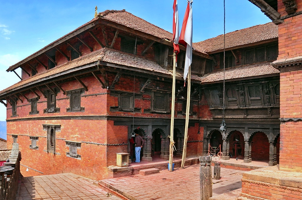
In the evening, we will reach Kathmandu and move to the hotel. We will enjoy a farewell dinner to celebrate completing the Manaslu Larke Pass Trek.
Maximum Altitude
1,400 m.Meals
B DTrek Duration
5 hrs + 8-9hrs driveAccomodations
HotelAfter breakfast, you will spend some free time in Kathmandu either shopping, sightseeing, or relaxing. Our guide will then take you to the international airport to board your flight.
As you leave Nepal, you carry unforgettable memories of the Manaslu Larke Pass Trek, the people you met, and the landscapes you explored.
We will say goodbye with warm wishes and hope to welcome you back again.
Meals
Breakfast
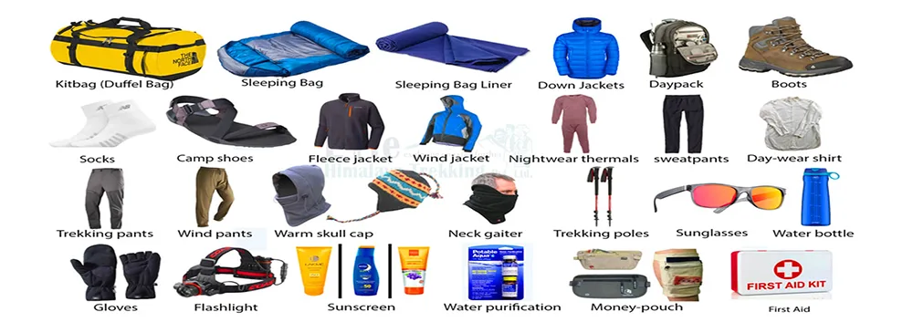
The Manaslu Larke Pass Trek is a long and demanding trek that requires good fitness and steady effort. On average, we will walk 5-7 hours a day on rough mountain paths, with stone steps, narrow paths, and some steep ascents.
The most physically demanding landscape is Larkya La Pass (about 5,106m), where it is thin in the air and the day is long.
Training for at least 3 to 4 months is advisable in order to prepare well. Cardio, such as walking, running, cycling, or swimming, should be given attention, and regular hill walks and stair training should be done.
Leg and core strength exercises are useful, and walking with a backpack should be practiced. Mental preparation is also a factor to consider since it is a remote road and there are basic facilities.
Altitude care is one of the most important parts of the Manaslu Larke Pass Trek. Our days above 3000 meters will be numerous, which is why we will have to walk slowly and give our bodies time to adapt.
The schedule will be a step-by-step increase in altitude, and we will have a day of acclimatization at Sama Gaon, 3500 meters, to ensure we get used to the higher altitude.
We will maintain a relaxed schedule each day, have brief breaks, and not rush. We should also drink sufficient water, and so we should target an average of 3 to 4 liters per day. Good eating is also beneficial, particularly rice, potatoes, noodles, and soup.
We should not take alcohol and sleeping pills as they can influence acclimatization. Other trekkers take Diamox only after a doctor’s consultation.
We are supposed to inform the guide early in case we develop a headache, nausea, or dizziness. In case of severe symptoms, the most secure treatment is to descend.
The best seasons for the Manaslu Larke Pass Trek are spring from March to May and autumn from September to November.
During these months, the weather is generally more predictable, the sky is clearer, and the mountain scenery is in best position. Spring is not so cold, and forests may be colored with blooming rhododendrons.
After the monsoon ends, autumn usually brings crisp air, stable days, and excellent mountain visibility.
Temperatures during the day are comfortable on lower levels, and at night they are cold with temperatures above 3000 meters. This means we will need warm clothes and a good sleeping bag.
The weather can shift unexpectedly in the mountains, even during mild seasons, and even then, snow can be found close to the pass.
In the monsoon season, it rains, the tracks are slippery, and there is a danger of landslides. In winter, it is very cold, and the Larkya La Pass may be covered with snow.
The Manaslu Larke Pass Trek is usually not recommended for complete beginners because it is long, remote, and reaches high altitudes above 5000 meters.
We require even-paced walking days, and we must take care of the altitude. Ideally, we should already possess some experience with multi-day treks and at least one trek experience of above 3000 meters.
Nevertheless, a first timer who is motivated still has the capacity to finish the trek, given that he/she trains well beforehand, walk at a slow pace, and accompany an experienced guide and support team.
The time spent at acclimatization is also part of the itinerary, although it also needs fitness and patience.
Beginners need to know that even with proper planning, altitude sickness may occur. If you are new to trekking, it might be wiser to complete a shorter trek, such as Annapurna Base Camp or Langtang, to get confidence. With the right preparation, the Manaslu Larke Pass Trek can still be achievable.
Altitude sickness can affect anyone during the Manaslu Larke Pass Trek because we sleep as high as 4480 meters and cross Larkya La Pass (about 5,106m).
The symptoms are common with headache, nausea, dizziness, tiredness, and shortness of breath, particularly at altitudes above 3000 meters.
Slow walking, adherence to the acclimatization plan, and daily intake of sufficient amounts of water are the most effective preventive measures.
Proper eating, non-alcohol use, and rest should be practiced. Our guide will follow up on how we all feel on a daily basis, and we need to report the symptoms early, even though they may appear minor.
Mild symptoms can be improved by rest, water, and remaining at the same altitude. When the symptoms get aggravated, the best thing to do is to move to a lower area.
Diamox is only taken by some people upon medical recommendation. It is essential to have adequate travel insurance with high altitude rescue, as in severe cases, helicopter evacuation might be required.
The Manaslu region is a restricted area, so permits are required for the Manaslu Larke Pass Trek, and trekking rules must be followed.
The trek should be accompanied by a licensed guide, and the regulation often involves at least two trekkers.
The primary permits are the Manaslu Restricted Area Permit, the Manaslu Conservation Area Permit, and the Annapurna Conservation Area Permit since the route egresses the Annapurna region.
TIMS is not usually needed in the restricted area trek of Manaslu. The principal permits that need to be obtained are the Manaslu Restricted Area Permit (RAP), Manaslu Conservation Area Permit (MCAP), and Annapurna Conservation Area Permit (ACAP).
The checking of permits occurs at various stages of the trail, at Namrung, and also at the exit point of Dharapani. It is important to remember when trekking that you have to carry a copy of your passport and original permits.
The trekkers are required to remain on the scheduled path, follow the local culture, and maintain the environment clean.
Individual trekking is not allowed in the restricted area, and a licensed guide is obligatory. Adherence to these regulations would preserve the culture, environment, and local people of this region.
Good health and safety planning makes the Manaslu Larke Pass Trek smoother and more comfortable. It is prudent to visit a doctor before traveling and check for some normal vaccines. Other vaccines, such as Hepatitis A and Typhoid, are also considered by many travelers.
We must also bring individual medications, blister treatment, and simple first aid supplies on the trek. Drinking water is a necessity, and boiled water, purification tablets, or a filter bottle should be used.
You also need sun protection since the UV is strong in the highlands, so you should use sunscreen, sunglasses, and a hat. A headlamp comes in handy during early mornings and power blackouts.
Communication may also be constrained, so you ought to notify the family of the itinerary prior to the trek. High altitude trekking and helicopter rescue travel insurance is highly recommended.
Above all, you must listen to the instructions of the guide, move cautiously on the narrow paths, and notify the guide in time when you are feeling ill.
During the Manaslu Larke Pass Trek, we will stay in local teahouses that are simple but welcoming. The rooms tend to be simple with twin beds or wooden platforms and thin mattresses, and therefore, a sleeping bag would be helpful, especially at elevations.
There is usually a shared bathroom, and not all places have hot showers, so we are supposed to be comfortable with basic facilities.
Nights are normally spent in a cozy dining room where the teahouse offers meals and hot beverages. Dal bhat, consisting of rice, lentils, vegetables, and occasionally pickle, is the most popular dish and a filling one, and has enough energy to trek.
Most of the villages also have soups, noodles, eggs, fried rice, pasta, Tibetan bread, and momo. There is a lot of vegetarian food, and it is also the safest at elevated levels.
We must wash our hands and consume safe water. Some places might provide charging and WiFi at a fee, but it might be restricted.
Transportation for the Manaslu Larke Pass Trek is done by road. Our trip will start with Kathmandu to Gorkha (approximately 6 to 7 hours), where we will have an opportunity to observe hills, rivers, and countryside life.
There is a possibility of some itineraries pushing further towards the point of origin, but it is dependent on the path.
Towards the end of the walk, we will arrive at the head of the road at Besishahar, and then we shall drive back to Kathmandu, which takes us approximately 8 to 9 hours.
The drive traced along the river valleys and mountain roads, with pauses on the way to take meals and rest. In some areas, the road is rough and bumpy, particularly after it has rained, but drivers are experienced.
When travelling along the road, you must have some Nepali cash to get snacks. No flights are made on this route; thus, the trip seems more tied down to local landscapes throughout.
Manaslu Larke Pass Trek is a great combination of mountain and cultural experiences. Mount Manaslu (8,163m) dominates the journey and can be viewed at areas such as Sama Gaon and close to Larke La Pass.
Trekking along, one also gets a glimpse of the Annapurna II, Ganesh Himal, Lamjung Himal, and other spectacular mountainous structures.
The peak of the journey is the Larke Pass, the highest point of the path, where panoramic views of snow-topped mountains and glaciers reward the tedious ascent.
A side hike to Manaslu Base Camp (4,880m) and adjacent Birendra Lake, available as an extension of Sama Gaon, provides serene glacial views.
The trek goes through the traditional Tibetan-oriented villages, which include Lho, Samdo, and Sama Gaon, where the monasteries, mani walls, and prayer flags depict the strong Buddhist culture.
The Manaslu Larke Pass Trek is an experience worth remembering due to natural hot springs at Tatopani, forest trails, alpine scenery, and wildlife views during the seasons.
If this is your first visit to Nepal, a little planning makes the Manaslu Larke Pass Trek easier. Your visa can be obtained upon entering Kathmandu airport, and it is better to carry passport photos and the necessary money.
You will have to exchange money in Kathmandu into Nepali rupees, since within the trek itself, there are no ATMs, and even teahouses tend to take only cash.
Learn the local culture. Be polite by saying Namaste, wearing modest clothes in villages, and seeking permission before taking photos.
It is quite convenient to pack such small items as hand sanitizer, toilet paper, and a refillable water bottle. To prevent stomach issues, you should consume cooked food and safe water.
The trail has a limited mobile network, so you ought to inform family in advance that you might be off the grid for a few days.
Lastly, in Nepal, it is common to tip guides and porters, and it is worthwhile to prepare a tip amount prior to the trek’s completion.
The Manaslu Larke Pass Trek passes through villages where Tibetan Buddhist culture is part of daily life, so cultural moments can happen even outside festival times.
Assuming that the date of our trek coincides with special occasions, we can observe such celebrations as Losar, the Tibetan New Year, which usually takes place in February and involves prayers, local festivities, and activities in monasteries.
During spring, there can be additional prayer sessions and visits to monasteries in Buddha Jayanti. Big Nepali festivals such as Dashain and Tihar are increasingly popular in towns and cities in autumn, but we might still see village families cooking offerings, decorating houses, or going to local shrines.
During the usual days, we can hear bells, observe incense, and people rotating prayer wheels in the evening. When we arrive at a monastery or at a ceremony, we must stand quietly, dress decently, and take the advice of the guide. Such cultural encounters make the trek meaningful.
Mobile network, internet, and charging facilities are limited on the Manaslu Larke Pass Trek, so trekkers should plan to be mostly offline.
The signal of Nepal Telecom or Ncell can be received even in lower villages, but the signal becomes weak with the altitude elevation. Mobile coverage in the higher areas is also patchy or non-existent.
Wi-Fi is also provided in some teahouses in bigger villages at a relatively higher charge, but tends to be very slow and unreliable because of terrain and weather conditions.
Electricity is scarce and is usually solar powered, and the charging is reserved only in some teahouses, usually in the evening and only at a small fee.
Trekkers should pack a power bank, extra batteries, and offline maps. The poor connection facilitates the use of this expedition as a digital detox and to fully experience the mountain atmosphere. Guides have alternative communication methods in case of an emergency.
The Manaslu Larke Pass Trek is a 23-day circuit trek in Nepal. It goes around Mt. Manaslu (8163m) and traverses Larkya La high pass (5135m). The trekkers explore the river valleys, Tibetan villages, and glacial landscapes with magnificent mountain scenery.
The trek lasts about 23 days, including arrival and departure in Kathmandu. Trekking itself covers roughly 17–18 days and about 120–150 km of walking. Daily trekking is 5–7 hours on average, with extra acclimatization days.
It is quite difficult. Expect steep, rocky trails for many days, often above 3000m altitude. A good fitness level and prior trekking experience are necessary. You train months in advance and pace yourself. With proper conditioning and the itinerary’s rest days, most active trekkers can complete it.
Spring (March–May) and autumn (Sept–Nov) are best. These periods have stable weather and clear skies. Spring brings warm days and blooming rhododendrons. Autumn offers crisp air and unobstructed mountain views. Monsoon season (Jun–Aug) is very rainy, and winter (Dec–Feb) brings snow, so they are not recommended.
See a travel doctor before the trip. Routine vaccines (MMR, polio, tetanus) should be up to date. Recommended vaccines for Nepal include Hepatitis A and Typhoid.
Rabies shots are optional, but not usually needed for typical trekking. There is no altitude vaccine; instead, prepare to manage altitude by acclimatization and possibly using prescribed medication.
Bring a personal first-aid kit (blister pads, painkillers, stomach remedies, etc.). Drink only boiled or treated water.
From Kathmandu, you can drive to Gorkha in 6–7 hours by tourist bus or jeep. The road winds through hills to reach Gorkha (1150m).
Some itineraries go via Arughat. Your trekking company provides this transport. The drivers are experienced, and there will be rest stops en route.
The trek finishes in Besishahar (760m). From there, you take a tourist bus or private jeep back to Kathmandu, a journey of about 8–9 hours.
The route follows river valleys (Marsyangdi, Trishuli) and mountains. Transport is arranged by your agency. You’ll reach Kathmandu in the evening of Day 22.
This trek is not recommended for absolute beginners. The length (23 days) and high altitude make it strenuous.
However, a very motivated beginner who does thorough training and goes with an experienced guide can attempt it.
The pace is slow, and support is given, but prior multi-day trekking experience is helpful. If you have never trekked before, consider a shorter trek first to build endurance.
Mobile coverage ends around Namrung (2630m). Beyond that (Sama Gaon, Samdo, Lho, and above), you should expect no cell service.
A few tea houses offer Wi-Fi (Jagat, Namrung), but it’s slow and often for a fee. Plan to be offline for most of the trek. Guide/group satellite communications handle emergencies.
Internet is very limited. Only a handful of villages have any wifi (and it is usually slow). Don’t rely on email or the web on the trail.
It’s best to download maps or music beforehand and enjoy the digital detox. You can catch up on the internet once back in Kathmandu or Pokhara.
Yes. You need comprehensive travel insurance that covers trekking up to at least 6000m and emergency helicopter evacuation. This is mandatory for this trek.
In case of serious illness or accident (like severe altitude sickness), you’ll want coverage for a possible airlift to a Kathmandu hospital. Keep a copy of the insurance details with you.
No. There are no ATMs in the mountains. ATMs exist only in Kathmandu or Pokhara (and maybe Arughat or Besishahar by luck).
Carry all the needed cash in Kathmandu. Credit cards won’t work on the trail. Plan your budget and have extra rupees for tips and souvenirs.
All payments on trek are in cash (Nepalese rupees). Teahouses and shops do not accept credit cards. Small stores may quote prices in USD but will want rupees or exact US bills.
Keep your cash secure (a money pouch or inside jacket). Distribute cash among your group if worried. Save small bills for meals and tips.
The local currency is the Nepalese Rupee (NPR). Exchange some US dollars or Euros in Kathmandu for rupees. Teahouses and shops along the trek operate in NPR.
Some permit offices take USD for permits, but on trek, spending is in rupees. Bring smaller denomination notes (100, 500, 1000 NPR) for convenience.
Wildlife sightings are rare. You might spot Himalayan birds like pheasants (danphe) or eagles. Monkeys or langurs sometimes appear in forests.
Occasionally, shy mammals (musk deer or red pandas) inhabit these valleys, but are seldom seen.
Mountain weather is unpredictable. In heavy rain or snow, your guide may delay the trek and wait out the storm at a teahouse.
If conditions worsen (heavy snow on the pass, rockfall), alternate lower routes or extra rest days are used.
Many trekkers tip about 10% of the trek cost. For a 23-day trek, that often means $100–150 USD for the guide and $50–100 for each porter.
Tips are given in cash on the last trekking day. You can adjust based on your experience and satisfaction. This gesture rewards the staff for their hard work.
Small shops exist in early villages (Arughat, Jagat, Namrung). They sell snacks (biscuits, chocolate), bottled water, and simple supplies. Above Jagat (Lho, Samdo, Dharamsala), there are no shops.
Buy all necessary gear (warm clothes, batteries, toiletries) in Kathmandu or early on. Teahouses also sell some snacks/drinks at a premium.
Alcohol (beer, whiskey) is available at a few teahouses (Jagat, Namrung, Samagaon). However, it is dehydrating and can worsen altitude effects.
It’s generally best to avoid alcohol while trekking. If you do drink, limit yourself. Many trekkers skip alcohol entirely to stay sharp at altitude.
Trekkers complete the route on foot, but supplies are often transported by porters and sometimes by pack animals on sections of the trail. Most travelers hire a porter to carry luggage while they trek with a daypack.
You get roughly 11–12 hours of daylight. In spring and autumn, sunrise is around 5:30–6:00 am and sunset is around 6:00 pm. Plan to start early to avoid afternoon clouds or storms, and to finish trekking by late afternoon.
Small rockfalls can occur, especially after rain. The trail is mostly stable, but caution is needed in narrow parts.
Major avalanches are very rare on the marked trail. Trekking during the monsoon does raise landslide risk, which is why that season is avoided.
Bring water purification tablets (Aquatabs) or a UV pen (Steripen). These let you safely drink from taps or streams. Many teahouses boil water, but treat all water yourself to be safe. Carry a refillable water bottle (1–2 L).
Mountains have simple medical facilities. A small health post may be found at Dharapani, and a first-aid post may be found at Besishahar.
The mountain guide has a first-aid kit. Anything more than basic care (severe AMS, injury) requires evacuation to Kathmandu. Helicopter evacuation may be organized (insured).

top rated - Based on 200 TripAdvisor & 93 Google Reviews
We plan custom and flexible holiday trips according to your holiday duration, extra wishes, and demands.
Plan your Trips
Chat with our Travel Designer Shiba
Need assistance? Our expert agent is here to help! Please fill out the form below to initiate a chat and get your queries resolved quickly.