
 English
 Dutch
Dutch Japanese
 Hindi
Hindi Italian
 Spanish
 French
 German
 Chinese
 Korean
 Arabic
 Hebrew
 Russian
 Portuguese
 Danish
 Czech
Czech Polish
 Swedish
 View the Trip Map
 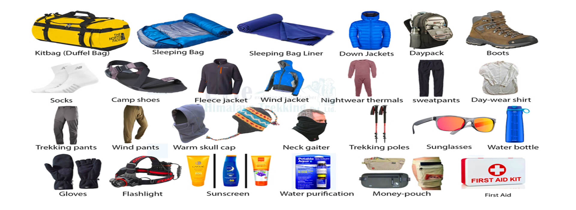 Equipment Checklist
 Plan Your Next
Journey to the Himalayas!
We plan custom and flexible holiday trips according to your holiday duration, extra wishes, and demands.
Plan your Trips


Max. Altitude
3800m
Best Season
Oct -Dec & March-May
Start / End Point
Kathmandu/KathmanduThe Kaligandaki River carves a deep passage between Himalayan giants, which is where the Kaligandaki Valley Trek is set. We walk this ancient cultural trail through changing natural environments. You move from forested hills to dry highlands with each step. Gurung communities build stone/clay homes on steep valley slopes. Last season our guides helped renovate a home of one of the locals in the region.
Later, he was given some fresh produce as their way of saying thank you. Their terraced fields show farming knowledge developed over many generations. Thakali villages cluster where rivers meet in the valley. You see white walled houses with carved wooden details. Tibetan cultural presence grows stronger near the sacred Muktinath Temple.
Prayer flags stretch across trails beside stone mani walls. Our team recently visited the temple and confirmed that the routes are as healthy as ever. Monasteries maintain spiritual practices unchanged through long periods of time. Villagers celebrate seasons with traditional music and colorful costumes.
Tibetan salt traders used these paths for centuries of exchange. Their routes connected distant Himalayan communities through shared history. You cross irrigation channels bringing water to crop fields today. Apple orchards mark our entry into the Mustang region. In 2024, our Kaligandaki Valley Trek group helped a local pick up all the apples off the ground. Pilgrims visit holy sites throughout the year for spiritual reasons.
This valley enabled cultural connections across mountain barriers naturally. Family run teahouses provide basic lodging along our trekking route. We share meals in rooms warmed by wood burning stoves. Porters carry heavy loads using time tested methods daily. You drink lemon ginger tea while talking with village elders. Our agency has trained many local women as trekking guides over the years.
So, if you are a group of females you can ask for a female guide as well. The local women are also largely responsible for the local markets. They sell handmade crafts, and fresh produce, alongside renting essential trekking supplies. Local guides share ancestral knowledge during our walking segments.
Weather patterns shift as we move between elevation zones. Morning mist clears to show mountain views in lower areas. Wind increases in higher sections requiring warm clothing layers. River sounds accompany our footsteps throughout the entire Kaligandaki Valley Trek. Last monsoon, the river sounds were extra thrilling as it sounded thunderous at certain points. You feel air temperature change crossing different ecological regions. Real cultural exchange happens through genuine daily interactions here.
You learn greetings from different ethnic groups we encounter. Families serve traditional meals prepared using time tested recipes. Evening conversations reveal practical mountain living wisdom naturally. Our guides organize a story session at some point during the trek where locals are free to chat for hours at night. This trek builds understanding through shared human experiences directly.
Communities demonstrate resilience in challenging mountain environments daily. Farmers grow food using techniques perfected over long periods. Villagers maintain stone buildings suited to local weather conditions. You watch elders teach young people traditional craftsmanship skills. One of our guides also got a chance to try his hands on crafts. The locals are very friendly towards visitors and will often invite them for tea or even meals.
The valley shows how people adapt to demanding landscapes successfully. Your participation supports local families through responsible travel choices. Trekkers become welcomed guests in village households along the route. Staying in community teahouses helps local economies thrive sustainably.
This authentic path creates lasting connections between different cultures. Our trekking groups over the years have funded and donated quite a lot to the less fortunate families of the region. The Kaligandaki Valley Trek offers one of Nepal’s most genuine trekking experiences.
We land at Tribhuvan International Airport at 1,400 meters elevation. Our team welcomes you with a traditional khada scarf welcome. You transfer directly to your Thamel district hotel. Kathmandu Valley spreads below 1,400 meters surrounded by forested hills. The city air carries dust, incense, and street food aromas.
You rest at this moderate altitude to recover from your flight. Our Kaligandaki Valley Trek guide checks your trekking permits and equipment this afternoon. You walk short distances to adjust to local conditions. Street vendors sell momos and fresh juice near your hotel. Evening temperatures drop requiring light jackets. Kathmandu’s historic Durbar Square remains open after reconstruction. You sleep early preparing for tomorrow’s long drive.
The city’s elevation provides a safe starting point for acclimatization. Street traffic considerably quiets after 10 PM allowing restful sleep. Our team confirms all travel documents before dinner. You eat dal bhat at a local restaurant to experience Nepali cuisine. Kathmandu’s energy feels intense after your flight. You notice prayer wheels turning at nearby stupas.
Maximum Altitude
1,334 m.Meals
DinnerAccomodations
HotelTransportation
Airport to Hotel TransferThe 200 kilometer Prithvi Highway journey takes seven to eight hours. Our Kaligandaki Valley Trek starts early, our vehicle leaves Kathmandu at 6 AM avoiding morning traffic. You pass terraced rice fields and small towns like Malekhu. The road follows the Trishuli River through narrow gorges.
We stop for tea at Muglin Bazaar where locals sell sugarcane juice. Elevation drops steadily from 1,400 meters to 822 meters in Pokhara. Road conditions worsen between Malekhu and Muglin with unpaved sections. You see porters carrying massive loads on their backs along the highway. The landscape changes from hills to flat valley plains near Pokhara. Phewa Lake appears with Annapurna South visible in clear weather.
Our driver navigates Pokhara’s crowded streets to your Lakeside hotel. You rest in your room overlooking the lake after the long drive. Pokhara’s air feels humid compared to Kathmandu’s dryness. We will confirm tomorrow’s trekking gear with you before dinner. You eat fresh meals at a lakeside restaurant as the sun sets. Streetlights reflect on Phewa Lake’s calm surface tonight.
Maximum Altitude
915 m.Meals
Breakfast and DinnerAccomodations
HotelTransportation
7 hours DriveWe drive 45 kilometers along the Seti to Nayapul. The two hour road trip ends at 1,010 meters elevation. You leave vehicles behind at this trailhead village. The Kaligandaki Valley Trek begins through subtropical forests with banana trees. Stone steps climb steadily beside beautiful waterfalls.
You cross three suspension bridges over tributary streams. Rhododendron and oak trees shade the first section of trail. The path passes Gurung villages where farmers work terraced fields. You gain 530 meters elevation over 11 kilometers to Tikhedhunga. Teahouses line the village center with basic wooden seating areas.
Tikhedhunga sits at 1,540 meters surrounded by steep hills. Evening brings cool mountain air requiring warm layers. Our guide points out medicinal and interesting plants along the trail. You wash with cold water at the teahouse tonight. The five hour trek builds initial leg strength for higher altitudes. Stone steps test your calf muscles more than flat roads.
Maximum Altitude
1,577 m.Meals
Breakfast, Lunch, and DinnerTrek Duration
5 hours TrekAccomodations
Local LodgeTransportation
90 minutes DriveStone steps climb continuously from Tikhedhunga’s edge. On the 4th day of the Kaligandaki Valley Trek, you ascend 1,320 meters over 12 kilometers today. Ulleri village marks the halfway point at 2,070 meters. The trail winds through dense rhododendron forests showing seasonal blooms. You pass water mills powered by mountain streams.
The path steepens near Banthanti with endless stone staircases. Ghorepani appears at 2,800 meters elevation on a ridge top. You see Annapurna South and Machhapuchhre peaks at sunset. Teahouses serve hot lemon ginger tea after we reach the destination of the day. Knees absorb impact on downhill sections between villages.
Local porters transferring goods short distance carry 30 or even 40 kilogram loads using head straps. Evening temperatures drop below 10°C requiring thermal layers. You eat vegetable thukpa for dinner in the communal dining room. The six hour trek tests significant cardio endurance. Ghorepani’s altitude demands extra water consumption. Sleep comes quickly after today’s physical challenge.
Maximum Altitude
2,810 m.Meals
Breakfast, Lunch, DinnerTrek Duration
6 hours TrekAccomodations
Teahouse LodgeWe descend immediately from Ghorepani’s ridge through oak forests. The path drops 865 meters over 10 kilometers to Shikha. You pass through Chitre village with traditional stone houses. Today’s Kaligandaki Valley Trek trail follows the Ghar Khola river valley downstream.
Suspension bridges cross multiple chilly streams today. Banana trees reappear as elevation decreases to 1,930 meters. You see farmers harvesting potatoes in terraced fields. Shikha sits beside the river at 1,930 meters elevation. Teahouses here use river water for cooking and washing. The four hour trek feels easier than yesterday’s climb.
Knees require careful footing on loose gravel sections. Evening brings warmer temperatures allowing lighter sleeping bags. You drink local fruit juice at a riverside teahouse. The descent prepares your body for tomorrow’s valley walking. Shikha’s location marks the transition into the Kali Gandaki gorge. You rest early anticipating Tatopani’s hot springs tomorrow.
Maximum Altitude
3,210 m.Meals
Breakfast, Lunch, DinnerTrek Duration
5 hours TrekAccomodations
LodgeToday’s Kaligandaki Valley Trek trail descends 740 meters over 15 kilometers to Tatopani. You follow the Kali Gandaki River through subtropical forest. Stone steps wind down steep valley slopes continuously. You cross multiple suspension bridges over tributary streams. Banana and mango trees grow along the riverbanks.
Tatopani means hot water referring to natural thermal springs. The village sits at 1,190 meters elevation near river confluence. You soak sore muscles in the hot springs after trekking. Evening temperatures reach 25°C in this lower valley. Teahouses serve fresh river fish for dinner tonight. The five hour trek includes challenging downhill sections.
Knee braces help reduce joint impact on steep descents. Local porters carry metal sheets or tins for local construction projects. You notice increased humidity compared to higher elevations. Tatopani provides essential recovery before tomorrow’s climb. Sleep comes deep after thermal spring immersion.
Maximum Altitude
2,920 m.Meals
Breakfast, Lunch, DinnerTrek Duration
6 hours TrekAccomodations
TeahouseOn day 7 of the Kaligandaki Valley Trek, we climb 820 meters over 14 kilometers from Tatopani to Ghasa. The trail follows the Kali Gandaki River upstream. Stone steps ascend steadily along cliffside paths. You cross a couple of suspension bridges over river channels. Ghasa appears at 2,010 meters elevation beside the river.
Teahouses here feature traditional stone architecture. The path passes through dense forest with pine and oak trees. You see farmers irrigating barley fields using river water channels. The four hour trek balances yesterday’s descent effectively. Ghasa serves as a key trading point for the Mustang region.
You eat dal bhat with locally grown vegetables. The climb today feels less strenuous than Ghorepani’s ascent. River sounds provide constant background noise at night. Ghasa’s elevation offers stable acclimatization conditions. You rest well preparing for tomorrow’s journey to Larjung.
Maximum Altitude
2,013 m.Meals
Breakfast, Lunch, DinnerTrek Duration
6 hours TrekAccomodations
LodgeThe next day, we trek 16 kilometers ascending 540 meters to Larjung. The trail follows the river through narrow canyon sections. Stone steps climb steadily between forested areas. Larjung sits at 2,550 meters elevation with Tibetan-style houses. The path shows increased Tibetan cultural influence today.
Prayer wheels and mani walls appear frequently along the route. Larjung features whitewashed buildings with intricate wood carvings. Teahouses serve butter tea and tsampa porridge tonight. The five hour trek maintains steady acclimatization progress. The night time temp can be a bit chilly tonight. You see farmers harvesting buckwheat in terraced fields. The village marks entry into Upper Mustang’s cultural zone.
Maximum Altitude
2,543 m.Meals
Breakfast, Lunch, DinnerTrek Duration
6 hours TrekAccomodations
LodgeOn the 9th day of the Kaligandaki Valley Trek, we walk 12 kilometers with minimal elevation gain to Marpha. The trail follows the Kali Gandaki River through apple orchards. Marpha sits at 2,670 meters above sea level famous for apple brandy. You pass through s tiny village with traditional stone houses.
The path includes flat riverbank sections and gentle slopes. Marpha features narrow streets lined with apple drying racks. Teahouses offer fresh apple pies and local brandy samples. You visit Marpha’s historic monastery with ancient murals. The three hour trek provides lighter activity after yesterday’s longer walk.
Evening brings cool mountains and you eat roasted buckwheat bread with honey for breakfast tomorrow. Marpha’s elevation offers stable conditions for acclimatization. Sleep feels restful after today’s relaxed walking pace.
Maximum Altitude
2,676 m.Meals
Breakfast, Lunch, DinnerTrek Duration
5 hours TrekAccomodations
LodgeThe following day, we trek 24 kilometers along the Kali Gandaki River to Eklebhatti. Today’s Kaligandaki Valley Trek gains 156 meters elevation over undulating terrain. Eklebhatti sits at 2,830 meters elevation near river confluence. You pass through Tukche village with traditional Tibetan architecture.
The canyon walls narrow creating dramatic landscape views. Irrigation channels bring river water to terraced crop fields. Eklebhatti features basic teahouses with solar power systems. The six hour trek covers a longer distance with plenty of ups and down, but minimal overall elevation change.
You see Tibetan traders transporting goods on horseback. Evening temperatures drop, requiring thermal layers for sleeping. Teahouses serve hearty vegetable stews for dinner tonight. The dry climate feels different from lower valley humidity. Eklebhatti’s location provides final acclimatization before Kagbeni. You rest well preparing for tomorrow’s entry into Upper Mustang.
Maximum Altitude
2,832 m.Meals
Breakfast, Lunch, DinnerTrek Duration
6 hours TrekAccomodations
LodgeWe cover 10.6 kilometers along the Kali Gandaki River today. The trail gains 95 meters elevation to Kagbeni’s 2,890 meters. Day 11 of the Kaligandaki Valley Trek features stone paths wind through narrow canyon sections with dramatic river views. You pass Kobang village with whitewashed Tibetan houses and ancient mani walls.
Kagbeni serves as Upper Mustang’s official gateway requiring permit verification. Strong canyon winds whip prayer flags constantly near the checkpoint. Three suspension bridges cross river tributaries before reaching the village. Teahouses here use solar panels for limited evening lighting.
One monsoon season we rerouted trekkers when flash floods damaged the main trail near Kobang. Our guides carry satellite phones for weather alerts in this canyon section. Evening temperatures drop to 12°C requiring thermal layers for sleeping. You eat dal bhat with buckwheat bread grown in local terraced fields.
Kagbeni’s 14th century monastery houses aesthetic murals requiring careful preservation. We’ve learned to schedule early arrivals here to avoid afternoon wind gusts.
Maximum Altitude
2,840 m.Meals
Breakfast, Lunch, DinnerTrek Duration
4 hours TrekAccomodations
LodgeOn the 12th day of the Kaligandaki Valley Trek, we will have to climb 14 kilometers ascending 815 meters to Muktinath’s 3,710 meters. The trail follows ancient salt trading routes through arid landscapes. You pass Jharkot village with stone houses clinging to canyon walls. The path steepens beyond Ranipauwa with loose gravel requiring careful footing.
Muktinath Temple features 108 water spouts and sacred flame shrines. Pilgrims perform rituals year-round regardless of weather conditions. Thin air affects breathing above 3,500 meters, demanding slower pacing. Just two months ago a client developed altitude sickness here; we administered oxygen immediately. She got down to safer elevation with the help of the guide.
Our guides carry portable oxygen canisters above 3,500 meters as standard protocol. Evening temperatures fall close to freezing, requiring heavy sleeping bags. You eat simple vegetable soup for easier digestion at this elevation. Clear morning views reveal Nilgiri peaks across the valley. We always check weather forecasts before this climb due to sudden snowstorms.
Maximum Altitude
3,802 m.Meals
Breakfast, Lunch, DinnerTrek Duration
6 hours TrekAccomodations
LodgeThe next day, we descend 16.7 kilometers, losing 990 meters elevation to Jomsom. Today’s Kaligandaki Valley Trek path follows the Kali Gandaki River through dramatic canyons. Jomsom sits at 2,720 meters with an operational Himalayan airstrip. Strong valley winds blow constantly requiring face masks to save yourself from the dust.
Our team members do not carry extra face masks, so you better come prepared. The last time we were here, it wasn’t as dusty, but it’s better to come prepared. Teahouses serve hot apple pies using Marpha’s famous orchard produce. You see the locals maintaining traditional weaving businesses here.
Evening temperatures reach 15°C providing relief from Muktinath’s cold. Porters transport construction materials using donkey caravans along this route. We time descents to arrive before afternoon winds intensify in Jomsom. Sleep comes easily after today’s steady downhill walking.
Maximum Altitude
3,802 m.Meals
Breakfast, Lunch, DinnerTrek Duration
3 hours TrekAccomodations
LodgeWe preferably choose flight instead of a drive down all the way to Pokhara. However, sometimes weather conditions might ruin our plan and have us drive to Pokhara instead. The twenty minute flight offers panoramic Himalayan views including Dhaulagiri. Road travel covers 149 kilometers through Beni and Kusma towns.
You see landscape shifts from arid Mustang to green subtropical valleys. Road conditions vary significantly after monsoon season damage. Last monsoon we had a one-of-a-kind bumpy drive to Pokhara. Our agency maintains relationships with locals for updates. Pokhara sits at 822 meters elevation beside Phewa Lake.
Evening brings mild 20°C temperatures ideal for lakeside walks. You eat fresh trout at restaurants overlooking the water. Lakeside district buzzes with tourists and souvenir shops until 10 PM. We always book lakeside hotels with river views for post-Kaligandaki Valley Trek relaxation. Teahouses provide hot showers after mountain accommodation. Sleep feels luxurious after transitioning from teahouse beds.
Maximum Altitude
2,713 m.Meals
BreakfastAccomodations
HotelTransportation
20 minutes FlightWe travel 200 kilometers along the Prithvi Highway to Kathmandu. The seven to eight hour drive passes through Muglin and Naubise towns. You see terraced farms on steep valley slopes throughout the journey. Road conditions improved after last year’s infrastructure upgrades.
We stop for tea breaks at roadside stalls selling samosas. Personally, our team members absolutely devour the combo. You should at least try samosa and tea once before moving onto other things. Kathmandu sits at 1,400 meters in a historic valley basin. Street traffic increases dramatically entering the city center.
You notice stronger urban smells of exhaust and street food. Thamel district provides familiar accommodation near trekking agencies. Our team confirms departure logistics during tonight’s dinners. You review photos documenting your entire Kaligandaki Valley Trek. Hotel beds feel exceptionally comfortable after mountain trekking.
Maximum Altitude
1,334 m.Meals
BreakfastAccomodations
HotelTransportation
8 hours DriveThe 16th day of the Kaligandaki Valley Trek is a sightseeing day. We visit Patan Durbar Square at 1,400 meters elevation. The UNESCO site features the 55-window palace and Bhimsen Temple. You walk through courtyards with centuries-old stone carvings. Patan Museum houses important Newari art collections. Street artisans demonstrate metal casting techniques before your eyes.
We have seen many of our tekkers getting inspired and amazed by the artistic value of this sightseeing tour. Lunch includes traditional Newari dishes like yomari and chatamari. Evening brings farewell dinner at a Thamel restaurant with live music. Our team presents certificates commemorating your trek completion.
You share stories about Kali Gandaki River valley experiences. The delicious meal features Nepali specialties prepared traditionally. Street lights illuminate souvenir shops until 10 PM tonight. We assist with last-minute gift purchases for family members. Hotel staff pack breakfast for tomorrow’s airport transfer.
Maximum Altitude
1,334 m.Meals
Breakfast, Farewell DinnerAccomodations
HotelWe transfer you to Tribhuvan International Airport two hours before flight. Morning light reveals Kathmandu Valley’s ring of forested hills. You complete departure formalities with our team’s assistance. Street vendors sell marigold garlands for good luck at the entrance. A few of our trekkers have gotten emotional while saying their goodbyes.
Our agency maintains a professional relationship, but also reflects the positive vibes that you offer. You reflect on elevation changes from 1,010 to 3,710 meters. The trek covered 117 kilometers through diverse cultural zones. You experienced Gurung, Thakali, and Tibetan communities firsthand.
Dal bhat fueled most meals with seasonal vegetable variations. You carry memories of Muktinath’s sacred water spouts. Kathmandu’s hills disappear below as the plane ascends.
Maximum Altitude
1,334 m.Meals
BreakfastTransportation
Hotel to Airport TransportWe meet you at Kathmandu airport with a traditional scarf welcome. You transfer directly to your Thamel hotel at 1,400 meters elevation. Our Kaligandaki Valley Trek team checks your trekking permits and equipment after you settle down initially. You rest at moderate altitude to recover from international travel.
A couple of seasons ago we introduced digital pre-arrival briefings reducing airport confusion by a lot. We provide a detailed briefing about the Kaligandaki Valley route tomorrow. Kathmandu’s elevation helps your body begin acclimatizing safely. Street vendors sell momos near your hotel for light evening meals.
We recommend early sleep after your long flight journey. You receive final gear checks before dinner at a local restaurant. Kathmandu provides essential initial preparation before mountain travel. Morning departure follows Prithvi Highway toward Pokhara valley.
The Kaligandaki Valley Trek demands moderate physical fitness across varied terrain. You walk 5 to 7 hours daily covering 10 to 24 kilometers. Stone staircases test your calf strength particularly between Ghorepani and Tikhedhunga. River valley descents strain knee joints requiring trekking poles. There is no way out of this, you have to walk for hours everyday if you want to complete the trek.
Elevation ranges from 1,010 to 3,710 meters challenging your prep. The Muktinath climb above 3,500 meters proves most strenuous. We schedule rest days for proper acclimatization at key points. Previous clients averaged 900 meter elevation gain on toughest days. Eighty percent of beginners choose our trekking pole rental service preventing knee injuries.
Proper footwear prevents blisters on rocky canyon trails. Our guides adjust pace based on group energy levels daily. You develop endurance through gradual daily distance increases. Weather changes require quick adaptation to trail conditions. Local porters demonstrate remarkable strength carrying 30 to 40 kilogram loads.
October through November offers ideal trekking conditions. Clear skies provide unobstructed mountain views during these months. Daytime temperatures range from 15°C to 25°C in lower valleys. December through February brings colder weather with possible snow above 3,000 meters. We do not rent sleeping bags, but we can recommend places to get them.
You require thermal layers for nighttime temperatures below freezing. March through May delivers warmer conditions and blooming rhododendrons. Monsoon season from June through September creates unfavorable trail conditions.
Last early winter, one of our trekkers got such a severe case of cold that he had to rest a couple days at a village. Spring temperatures reach 20°C in Pokhara valley during the daytime. October remains our most popular booking period for stable conditions.
Most of the beginners we have taken along have completed the Kaligandaki Valley Trek with proper preparation and guidance. We require three months of consistent cardio training before departure. Previous clients with no trekking experience succeeded through gradual acclimatization. You walk shorter distances during initial Kathmandu and Pokhara days.
Our beginner support program includes pre-trek tutorials learned by most of our new trekkers. Our guides adjust periodic rests based on your energy levels and breathing. Stone staircases present the biggest challenge for inexperienced walkers. Trekking poles reduce knee strain during valley descents significantly. We monitor your oxygen saturation levels above 3,000 meters elevation.
Beginners might need extra rest days at Ghorepani and Marpha locations, if you feel like you will need them, let us know before you book the Kaligandaki Valley Trek package. Last year 78 percent of beginners upgraded to our guided breathing workshops. You develop strength through daily walking rather than intense workouts. Hydration discipline proves more critical than raw fitness levels.
Altitude sickness affects about 25 percent of trekkers above 3,500 meters elevation. Symptoms include headaches, nausea, and sleep disturbances at higher camps. We ascend gradually keeping a close eye on the daily elevation gains. Our Kaligandaki Valley Trek guides carry portable oxygen canisters above 3,000 meters routinely.
You drink 3 to 4 liters of water daily to prevent dehydration effects. Diamox medication reduces symptoms when taken preventatively. We schedule mandatory rest days to let your bodies adapt well to the changes. Last season our early detection protocol prevented many severe cases. Immediate descent remains the only cure for severe altitude sickness next to calling an emergency helicopter for rescue to the nearest medical facility.
Oxygen saturation checks occur twice daily above 3,000 meters. You recognize early symptoms through our pre-trek educational session. Proper acclimatization prevents 90 percent of serious altitude cases. Sleep quality slightly decreases above 3,000 meters requiring warm sleeping bags.
Teahouses provide basic accommodation throughout the Kaligandaki Valley Trek route. Rooms feature twin beds with shared toilet facilities at most locations. You receive mattresses, blankets, and pillows at every stop. Meals center around dal bhat, rice, lentils, and vegetable combinations. Our food safety program reduced stomach issues by large last season.
Teahouses offer hot lemon ginger tea and boiled drinking water. Breakfast includes porridge eggs, pan cakes, tibetan bread, and chapati bread. Apple pies feature prominently in Marpha region teahouses. You pay 300 to 500 Nepali rupees for extra meals at higher elevations. Clients should let us know their dietary preference at the time of booking.
Water purification tablets ensure safe drinking water between settlements. Teahouse dining rooms provide communal seating with wood stove heat. Solar panels supply limited electricity for phone charging at most of the stops. Most teahouses lack running hot water requiring bucket showers.
We arrange comfy vehicles for Kathmandu to Pokhara highway travel. The 200 kilometer journey takes 7 to 8 hours along Prithvi Highway. Road conditions vary from paved sections to rough dusty sections. Flight options exist between Jomsom and Pokhara when weather permits. Our clients using flight coordination service save 5 hours versus road travel.
Tara Air operates daily flights from Jomsom airstrip to Pokhara. Helicopter transfers remain available during road closure emergencies. Our vehicles undergo weekly mechanical inspections for safety. Drivers carry satellite phones for communication in remote areas. Although we have never run into any emergency issues while driving, we always have the drivers carry the necessary tools.
We maintain partnerships with a few of the locals for road construction updates. Road travel provides more landscape variety than flight options. All drivers hold valid commercial licenses and are sound of health. Vehicle capacity matches group size with one spare seat minimum.
You require two essential permits for this trekking route. The ACAP permit costs 3000 Nepali rupees for foreign nationals. TIMS card registration costs 2000 Nepali rupees through trekking agencies. Both permits undergo verification at Kagbeni checkpoint entering Upper Mustang. Our digital permit processing cuts paperwork time by half for returning clients.
We process permits through registered trekking agencies in Kathmandu. Permit processing takes two business hours with your passport copy. Authorities reject incomplete applications missing passport sized photographs. You carry original permits throughout the Kaligandaki Valley Trek journey. Police checkpoints inspect permits daily between Kagbeni and Jomsom.
Permit fees fund local trail maintenance and community projects. Last year improvements on the trail were made all thanks to the proceedings of the permits. We include permit costs in your initial trip quotation. Lost permits require immediate replacement through our Kathmandu office.
Start cardiovascular training three months before your trekking date. Walk 5 kilometers daily building to 15 kilometer distances gradually. Incorporate stair climbing sessions twice weekly for stone step preparation. Strengthen leg muscles through squats and lunges at home gyms. Our beginner training program includes live sessions with trek experts.
Break in your trekking boots on local trails before departure. Pack layers including thermal innerwear and waterproof outerwear. Consult your physician about altitude medication requirements beforehand. We provide detailed packing lists through our pre-trip email system. Clients can rent trekking gear from local shops in Kathmandu.
All of our previous clients who trained with weighted backpacks for trail simulation did very well throughout the Kaligandaki Valley Trek. Hydration practice ensures you drink 3 liters daily. Fitness level directly impacts your daily trekking distance capability.
The standard route follows the Kali Gandaki River valley floor. Shorter options skip Upper Mustang returning from Marpha to Pokhara. Longer variations include Annapurna Circuit connections near Ghorepani. Jomsom to Muktinath helicopter tours save one full trekking day. Our custom route planning service created over a dozen personalized itineraries last year.
Alternative paths might avoid Tatopani hot springs during monsoon landslides. Last season we used the Larjung to Tukche detour for a more remote experience. Shorter itineraries complete in 12 days instead of 17 days. Clients choosing our photography-focused route capture significantly more summit shots.
Standard packages range from $_____ to $_____ per person. This includes Kathmandu hotel Pokhara accommodation and teahouse stays. Meals and drinking water form part of the inclusive pricing structure. Transportation covers Kathmandu to Pokhara road travel, Pokhara to Nayapul, and return.
Our price lock guarantee protects against sudden permit fee increases. Permits and guide porter services remain included in base pricing. International flights and travel insurance require separate payment.
Teahouses charge phones for 100 to 300 Nepali rupees per session. Solar power provides limited electricity at higher elevation locations. Power banks prove essential for daily gadget charging needs. Internet access remains available through Ncell SIM cards. Our SIM setup service gets clients connected within a day of arrival. Purchase local SIM cards in Kathmandu for 500 Nepali rupees. While most of our clients get data packages, the coverage isn’t that great in the remote villages.
International flights represent your largest pre-trip expense. Travel insurance costs $100 to $200 depending on coverage level. Visa fees total $30 for 15 day Nepal entry permits. Although we would like to help you extend your stay in Nepal, there’s nothing we can do to help in your visa extension process. It’s fully government controlled.
Teahouse hot showers require 200 to 500 Nepali rupee payments. Souvenir shopping averages $50 for most travelers. Usually while buying souvenirs, our guides have saved trekkers from over paying and also helped them find the best value.
Day 10 requires trekking for over 20 km with a net elevation gain of 156 meters. However, the cumulative gain throughout the day is much higher including constant ups and downs.
Yes, you can spend extra nights wherever you prefer to, with a pre arranged setting. The extra cost of the stay will be adjusted in the total price of the Kaligandaki Valley Trek package.
The major difference would be the geographical features and the availability of modern services. While lower mustang has no shortage of infrastructures, the upper mustang region is a bit behind on development.
The locals do not expect international visitors to know specific culturally appropriate things, they get a pass when they make innocent mistakes. However, always be respectful of the practices and norms.
The hot spring bathing sessions in Tatopani are free. You do not have to pay a single penny.
No fresh produce disappears from menus above 3000 meters, they just get pricier.
As we head deeper into the valley, LPG is replaced by firewood and kerosene stoves. In addition to that, less spices are used to make food as they are hard to come by.
Usually, you get thicker mattresses and better insulation in river valley accommodations. High mountain ones often have colder room and thin mattresses because of their remote nature.
Any form of resources in the remote villages are highly limited. Things such as water, solar power, firewood, etc. are scarce, so to save them as much as possible, limitations are made.
It’s not about speciality, it’s about the freshness of the produce. If you look at its content, it is similar to generic brands, but the freshness is unmatched.
The infamous staircase of Ulleri village is physically demanding. However, with periodic rests, you can cross it eventually.
The trek starts at lower hills and reaches the arid landscape of upper mustang where cold and dry weather is the default. To better dress for each scenario, we require different thermal layers.
A bottle capable of holding 2 to 3 litres of wTer should be enough for the daily treks of the Kaligandaki Valley Trek.
Yes, trekking poles are helpful for every trekker on this route, not just the beginners. It supports your body during ascents and descents.
Altitude sickness often creeps up on trekkers after they cross 3500 meters above sea level.
Knee injury risks are notorious for cutting the trek short. Trekkers who get injured in the knee are often seen ending the trek on the spot. To avoid it, you must train your quads appropriately.
There are medical posts in most of the villages along the way. If the case is serious, you will be escorted by an emergency helicopter.
Our experienced guides use a dedicated device to measure your oxygen levels everyday after dinner and before breakfast.
If the flight is cancelled, we will have to opt for a jeep ride instead. This will take a few hours but we will reach Pokhara by the end of the day.
No, there are no active landslide zones en route. However, landslides can occur if the conditions are met. Although the chances are low, it’s not zero.
After the monsoon season officially ends, the Prithvi Highway does change in any way since it has been newly patched.
Road closures are rare cases when travelling from Pokhara to Nayapul. If natural calamities disrupt the road, it could take 6 to 8 hours to clear the debris.
Upper mustang is one of the restricted regions of Nepal as it holds high cultural value. Despite the westernisation in all the different parts of the country, most of the upper mustang region remains culturally pure.
Winter is the most budget friendly out of all the other seasons since it is the down season and there aren’t many visitors around. The price of our Kaligandaki Valley Trek package also drops.
As we go higher into the valley, even simple resources and food options are limited. Accommodation costs remain minimal but food costs are usually higher.
One guide is arranged for a group of 6 trekkers. If there are more trekkers in a group, assistant guides will be arranged as required.
As per the standard practice, two trekkers share a single porter, who will carry a total of 25 kg load throughout the trek. So a group of four trekkers will have 2 porters supporting them, unless you require more at additional price.
Our guides have been trained for worst case scenarios and they know how to handle altitude sickness and minor injuries.
As you get to higher altitudes, the oxygen concentration in the atmosphere depletes slowly. Some trekkers find it hard to breathe at certain points throughout the trek, so a portable oxygen canister is very handy in such situations.
Support staff immediately call the emergency service providers in emergency cases. The also help you get down to lower elevation or the pickup spot of the helicopter.
A 50 percent deposit enables us to book your accommodations, transport vehicles, driver, porters, guides, etc. It also lets us know that you are in for the trek, not just an unsure traveler.
If route changes occur during the trekking days, we will let you know as soon as possible. Generally, route changes happen due to natural calamities or construction.
Our travel agency accepts credit card and cash payments. You can also pay us digitally via your banking app.
To make sure that we are dealing with serious trekkers, we need a certain amount of deposit. This deposit also helps us make the necessary pre arrangements before you even land in Nepal.
Based on the time of cancellation, you will be refunded after deducting a certain amount as service fees. This fee will be based on how late or early the trek has been cancelled.
The valley of Upper Mustang falls in the rain shadow of the high and mighty Annapurna Himalayan range. It receives very minimal rainfall even in monsoon. The wind swept clouds are all blocked by the high mountains making the region sunny throughout the year.
During the nights, temperatures can reach under 10 degree Celsius, and the daytime temp remains at an average of 20. To make sure we are appropriately dressed, you need to pack the right clothes in your luggage.
Spring is the most jam packed season out of all, followed by autumn. These are the top two choices of trekkers.
With your kids, you can do this trek at any point throughout the year. When it comes to elderly people, make sure that they are physically capable of handling long walking distances.

top rated - Based on 200 TripAdvisor & 93 Google Reviews
We plan custom and flexible holiday trips according to your holiday duration, extra wishes, and demands.
Plan your Trips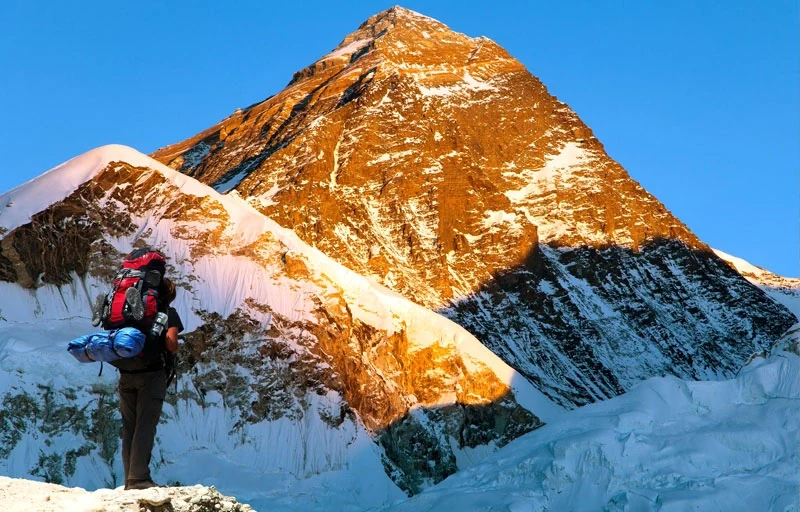
Chat with our Travel Designer Shiba
Need assistance? Our expert agent is here to help! Please fill out the form below to initiate a chat and get your queries resolved quickly.