
 English
 Dutch
Dutch Japanese
 Hindi
Hindi Italian
 Spanish
 French
 German
 Chinese
 Korean
 Arabic
 Hebrew
 Russian
 Portuguese
 Danish
 Czech
Czech Polish
 Swedish
Plan Your Next
Journey to the Himalayas!
We plan custom and flexible holiday trips according to your holiday duration, extra wishes, and demands.
Plan your Trips
If you thought your toughest decision today would be choosing between tea or coffee, wait till you ask yourself how to reach from Tengboche to Dingboche. Waking up early around 7 am, you’ll be warmly welcomed by the stunning views of the Ama Dablam, glowing in the morning mountain sun. There are a lot of alternative routes to reach Dingboche, but the best and most popular one is the main trail that passes through Shomare and Orsho.
Several alternative routes include the Upper Pangboche Shortcut, the route via Pheriche, and the High Trail via Milingo. All these alternative routes finally meet just a few minutes before Dingboche, which stands at 4,410 meters. You’ll gain nearly 600 meters of elevation either way, but you won’t face any problems while descending with proper acclimatization and preparation.

Best Ways to Reach Dingboche from Tengboche If you thought your toughest decision today would be choosing between tea or coffee, wait till you ask yourself how to reach from…
This first route is the standard and most used route to reach Dingboche from Tengboche. It takes about 5 to 6 hours to cover a distance of around 10 to 11 kilometers. The path is well-marked and nicely managed as compared to other routes. Starting from Tengboche, you’ll first pass through Debuche village, then walk alongside the Imja Khola, a tributary to the Dudh Koshi River. The trail continues to Pangboche, home to the famous Pangboche monastery, one of the oldest monasteries in the Khumbu region. If you’re lucky, you can witness local festivals or Buddhist ceremonies that are very popular here.
After Pangboche, you’ll move towards Shomare and then Orsho, where you can encounter dramatic views of Ama Dablam, Nuptse, Lhotse, and Makalu. This route is mostly loved by the trekkers because it offers better acclimatization and more views. It also provides a mixed journey including forest paths, stone-walled fields, and open alpine terrain. From Orsho, you’ll move towards your final destination, Dingboche. The views get even more dramatic, and the air becomes thinner.
| Route Name | Route Description | Notes |
| Upper Pangboche Shortcut | Tengboche to Upper Pangboche, Orsho, and finally Dingboche | More panoramic, fewer people, steeper, passes through the oldest monastery in the region |
| Alternative via Pheriche | Tengboche to Debuche, Debuche to Pangboche, Shomare, Orsho, Pheriche, and eventually Dingboche | Used for medical stop (HRA clinic), often used during descent or rest days |
| High Trail via Milingo | Tengboche to Milingo, Milingo to Upper Pangboche, Orsho, and finally Dingboche | Rarely used, remote, used mainly by guides or locals, not very popular among trekkers |
Along the trail to Dingboche, you’ll find plenty of teahouses in villages like Debuche, Pangboche, Shomare, and Orsho, making it easy for you to rest, eat, and acclimatize properly. Many trekkers stop for lunch in Pangboche or Shomare, both offering good food and mountain views. These teahouses also provide perfect lodging and are great for acclimatization as you gain altitude. Mobile networks may be irregular, but some teahouses offer WiFi for a small fee. However, don’t you expect really fast internet in the Himalayas.
For essentials, make sure you have the required permits: Sagarmatha National Park and Khumbu Pasang Lhamu Rural Municipality Permit. Carry at least 1.5 to 2 litres of water, with purification tablets or a filter, as water resources are present but they are not always safe to drink. Wear layered clothing, carry a first aid kit and waterproof backpack, and prepare physically and mentally before the trek. The route can be safe for experienced trekkers to trek alone, but hiring a guide or porter is highly recommended for safety, local knowledge, and support.
Tips: Pack light, but not too light- unless you want to borrow socks from a yak or share snack bars with mountain goats.

Premium Everest Base Camp Trek – 9 Days
Best Ways to Reach Dingboche from Tengboche If you thought your toughest decision today would be choosing between tea or coffee, wait till you ask yourself how to reach from…
| Season | Temperature | Good to go? | Reasons (Why or Why not?) |
| Spring | 10°C to 15°C (Day) -5°C to -10°C (Night) | Yes | clear skies, blooming rhododendrons, picturesque stupas, spectacular views of Ama Dablam and Island Peak. |
| Summer/Monsoon | 12°C to 18°C (Day) 0°C to 5°C (Night) | Not ideal | Trails get muddy and slippery, clouds hide the sweeping views, leeches, and poor visibility affect the vistas |
| Autumn | 8°C to 14°C (Day) -5°C to -12°C (Night) | Yes | Crystal-clear skies, panoramic mountain views, colorful festivals, cozy teahouse hospitality |
| Winter | 0°C to 5°C (Day) -10°C to -20°C (Night) | Challenging (but you can go) | Very cold nights, fewer crowds, snow-covered landscapes. Good for memories and raw beauty if well-prepared. |
The trail of Tengboche to Dingboche trek isn’t just filled with mountain views and colorful prayer flags; it’s also home to many traditional Himalayan medical plants. Locals have used these herbs for centuries to treat everything from altitude sickness to stomach pains. You’ll find:
These plants are more than just greenery; they’re deeply tied to Sherpa culture. After finding them, you may think of taking some part of them, but remember that many of these herbs are fragile and protected. It’s best to admire, photograph, and learn, not to pick. So, as you walk the beautiful path of the Everest Base Camp trek, especially between Namche and Dingboche, keep an eye out, not just for views, but also for herbal secrets growing quietly trailside.


We plan custom and flexible holiday trips according to your holiday duration, extra wishes, and demands.
Plan your Trips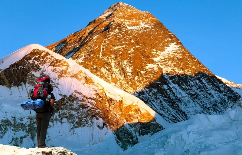
Chat with our Travel Designer Shiba
Need assistance? Our expert agent is here to help! Please fill out the form below to initiate a chat and get your queries resolved quickly.