
 English
 Dutch
Dutch Japanese
 Hindi
Hindi Italian
 Spanish
 French
 German
 Chinese
 Korean
 Arabic
 Hebrew
 Russian
 Portuguese
 Danish
 Czech
Czech Polish
 Swedish
Plan Your Next
Journey to the Himalayas!
We plan custom and flexible holiday trips according to your holiday duration, extra wishes, and demands.
Plan your Trips
The 10 highest mountains in Nepal, including Mount Everest, Kanchenjunga, Lhotse, Makalu, Cho Oyu, Dhaulagiri, Manaslu, Annapurna I, Machapuchare, and Annapurna II, stand as towering giants that define the country’s dramatic landscape. Lying on the lap of the Himalayan range, Nepal is recognized as a country of excellent landscape beauty and has been accredited for its towering mountains.
This small but rather heterogeneous country takes pride in being the home of eight of the world’s fourteen tallest peaks, Mount Everest. Its geographical features entail a gorgeous landscape with mountains, fabulous valleys, and forests, which have been capped with snow, an added advantage to hiking and nature lovers.
To climbers and trekker travelers, the mountains of Nepal are not just geographical features but symbolisms of challenge and achievement par excellence. Despite being very high and relatively untouched, people from around the globe are attracted to such big mountains. It is likely the Great Adventure of the world’s Everest, the Himalayan Promotion of the famous Annapurna Circuit, or the pleasant walks of Langtang Valley Trekking.
Mount Everest, standing at 8,848.86 meters, is the world’s highest peak. It holds a prestigious global ranking as the ultimate summit for climbers. Everest is situated in the Mahalangur Himal sub-range of the Himalayas, straddling the border between Nepal and China.

Sir Edmund Hillary and Tenzing Norgay achieved the first successful ascent of Everest on May 29, 1953. Since then, it has seen numerous notable climbs, with climbers from various backgrounds and skill levels attempting to reach its peak.

Mount Everest Expedition – 55 Days
The 10 highest mountains in Nepal, including Mount Everest, Kanchenjunga, Lhotse, Makalu, Cho Oyu, Dhaulagiri, Manaslu, Annapurna I, Machapuchare, and Annapurna II, stand as towering giants that define the country's…
Summit Details
The summit of Mount Everest is characterized by its extreme altitude, where the air pressure is about one-third of that at sea level. Climbers face harsh conditions, including freezing temperatures, high winds, and no oxygen.
Unique Challenges and Conditions
The primary challenges of climbing Everest include severe weather conditions, the risk of avalanches and crevasses, and altitude sickness due to the thin air. The “Death Zone” above 8,000 meters presents climbers with hazardous conditions, including frostbite and cerebral or pulmonary edema.
The Everest Base Camp Trek is a busy route since it allows one to witness the beauty of the Himalayan mountains and the culturally rich area of the Himalayas without attempting to climb Mount Everest. The trek typically takes between 12 and 14 days, permitting the trekkers to look at fantastic eruption views and other mountains with a chance of acclimatization.
Climbing Routes and Permits
The standard climbing routes on Everest are the South Col Route from Nepal and the North Ridge Route from Tibet. Climbing Everest requires a permit from the respective government authorities: the Nepalese government for the South Col Route and the Chinese government for the North Ridge Route. Climbers must also navigate extensive logistics, including securing permits, hiring experienced guides, and preparing for high-altitude conditions.
Kangchenjunga, with a height of 8,586 meters, is the third-highest mountain shared among Nepal, the Republic of India, and Bhutan. Due to its great height, it now serves as a landmark of great importance in mountaineering worldwide. George Band and Joe Brown achieved the first successful ascent of Kangchenjunga on May 25, 1955. This climb is notable for its pioneering spirit, as the mountain’s remote location and challenging conditions have long made it a coveted goal for climbers.

The 10 highest mountains in Nepal, including Mount Everest, Kanchenjunga, Lhotse, Makalu, Cho Oyu, Dhaulagiri, Manaslu, Annapurna I, Machapuchare, and Annapurna II, stand as towering giants that define the country's…
Unique Characteristics and Challenges
Kangchenjunga is known for its two steep, massive mountains. Its five summits add to the range’s beauty. The hill is isolated, and there are many glaciers. So, climbing and trekking are now more challenging. Climbers face storms, wind, and rugged terrain. So, it’s less popular and more complex than Everest.
The Kangchenjunga base camp trek shows you the mountain’s vastness. It takes you through the jungle, hills, fields, and meadows. This trek generally takes about 18- 22 days, giving the hikers an excellent chance to visit some of the cultural villages in the area.

Climbing Permits and Routes
To attempt Kangchenjunga, one must obtain permission from the Nepalese authorities. The South Face Route is the main ascent. It requires severe tests of a climber’s skills. Climbing Kangchenjunga is complex. So, climbers must take some steps. They must get permits, hire experienced guides, and manage high-altitude risks.
Lhotse, with an elevation of 8,516 meters, is the fourth-highest mountain in the world. Lhotse is in the Himalayas, directly south of Mount Everest. It lies on the border between Nepal and Tibet. The closest base in Nepal is the Everest Base Camp. From there, climbers approach Lhotse’s southern routes.
It is closely related to Mount Everest, which shares a base with it and forms a continuous ridge. Swiss climbers Ernst Reiss and Fritz Luchsinger achieved the first successful ascent of Lhotse on May 18, 1956. It is often climbed in conjunction with Everest expeditions.

The 10 highest mountains in Nepal, including Mount Everest, Kanchenjunga, Lhotse, Makalu, Cho Oyu, Dhaulagiri, Manaslu, Annapurna I, Machapuchare, and Annapurna II, stand as towering giants that define the country's…
Features of the Peak and Climbing Difficulties
Lhotse is known for its steep, challenging climbing routes. The Lhotse Face, a sheer ice wall, is a notable challenge. Climbers must navigate it to reach the summit. The mountain consists of steep faces of ice and rocks. The climber requires a high level of technical ability and physical fitness. The Lhotse Face is upward and much more prone to the avalanche and the darkest cold, hence, a severe challenge.
The main route on Lhotse involves climbing the Lhotse Face. It’s a tricky section of ice and rock that connects to the South Col route. Climbers often follow the Everest route up to the South Col before tackling Lhotse. This route requires careful acclimatization. The high altitude and technical climbing make the ascent demanding.
Climbing Permits
Climbing Lhotse requires a permit from the Nepalese government. Since it is often climbed with Everest, climbers usually obtain combined permits. It requires detailed planning. This includes getting licenses, hiring guides, and preparing for high-altitude climbing.
Makalu, standing at 8,485 meters, is the fifth-highest mountain in the world. One might recognize it for its pyramid design, which adds to the ensemble of its grandeur and, at the same time, a tough climb. Thus, Lionel Terray and Jean Couzy attempted to sum up Makalu on May 15, 1955. Due to its isolation and the onset of harsh weather, it became an elite mountain in climbers’ eyes.
Makalu lies in the eastern Himalayas, in Nepal’s Mahalangur group. It lies near the Tibet border and is hard to access. The only way to approach the mountain is via Tumlingtar in eastern Nepal. After reaching Tumlingtar, the trekkers head towards the Makalu Base Camp, where the climbs begin.

The 10 highest mountains in Nepal, including Mount Everest, Kanchenjunga, Lhotse, Makalu, Cho Oyu, Dhaulagiri, Manaslu, Annapurna I, Machapuchare, and Annapurna II, stand as towering giants that define the country's…
Difficulties and Climbing Challenges:
Makalu is famous for its steep ROCK CLIMBING and crud sharp ridges and faces. It has some tricky ice and rock faces. Its height exposes climbers to freezing weather and strong winds. The mountain’s geography needs to be improved. It is one of the most remote places to climb. So, one must be ready to spend much time exposed to harsh conditions.
The Makalu Base Camp trek is fantastic. It inspires trekkers with views of Makalu and other peaks. The walk takes 18 to 20 days. The paths run through temperate forests, alpine pastures, and steep trails. It provides an option for exploration of the natural and cultural attributes of the Makalu area.
Climbing Routes and Requirements
Makalu has two climbing routes: the Southeast Ridge and the West Pillar. Both are technically challenging. Due to the climber’s troublesome nature, one needs a permit from the Nepalese government to attempt Makalu.
Other things include hiring experienced guides and preparing for high altitude. The climb is brutal. So, climbers must prepare for its harsh conditions. They need to acclimatize to the altitude and the severe weather.
Cho Oyu, standing at 8,188 meters, is the sixth-highest peak in Nepal. It is in the Himalayas, on the border between Nepal and Tibet. Its lower altitude than other 8,000-meter peaks makes it more accessible. It’s often seen as a great intro to climbing those peaks.
A British team led by Sir Edmund Hillary and Tenzing Norgay achieved the first successful ascent of Cho Oyu on October 19, 1954. Its appeal is that it is challenging but doable climbing. It attracts many climbers who want to summit an 8,000-meter peak.
Features and Climbing Conditions
Despite being the sixth-highest mountain in Nepal and Compared to other 8,000-meter peaks, Cho Oyu has gentle slopes. This makes it less technically demanding. However, climbers still face challenges. They include high winds, cold temperatures, and thin air at high altitudes. The route typically involves a mix of ice and snow climbing, with the most common approach being the Northwest Ridge.
The expedition to Cho Oyu involves a trek to the base camp and a challenging climb. The trek usually starts in Kathmandu. It then goes to the Tibetan border and the base camp, the staging area for the climb. The route includes climbing high camps and a tricky ice and snow section.
Climbing Cho Oyu requires a license from the Chinese government, as the mountain is located in Tibet. Climbers also need to arrange a Tibetan climbing permit and, often, a liaison officer. Preparation includes getting permits, hiring expert guides, and readying for high-altitude conditions. To succeed, climbers must prioritize acclimatization and preparation. This mountain is one of the more accessible 8,000-meter peaks.
Mount Dhaulagiri is located in the north-central part of Nepal, in the Dhaulagiri Himal range. It is the seventh highest mountain in the world, with a height of 8,167 meters. It is also known as white mountain. As a proportional mountain, it looks tremendous. It is one of the tallest in the Himalayas.

Dhaulagiri, being the tallest, was first climbed by a Swiss team under Kurt Diemberger on May 13, 1960. Due to its size and difficulty level, it has earned its place and become a focal goal for most professional climbers.

The 10 highest mountains in Nepal, including Mount Everest, Kanchenjunga, Lhotse, Makalu, Cho Oyu, Dhaulagiri, Manaslu, Annapurna I, Machapuchare, and Annapurna II, stand as towering giants that define the country's…
Summit Challenges and Characteristics
Climbing Dhaulagiri is hard. It has high winds, very low temps, and challenging sections. The climbings become even more difficult since the mountain has ice and rock faces, the steepest being the northeastern ridge. The route includes a technical glacier where individuals climb icefalls and technical sections. Therefore, there is a vast need for technical and physical skills first and foremost.
The Dhaulagiri Circuit Trek is one of the most famous treks in the region, and trekkers get beautiful views of Dhaulagiri and other mountains. This trek usually lasts 16-20 days. It covers the arid Great Himalayan range, arched wheat and corn fields, virgin forests, and a vast desert. The circuit also passes through the French Pass (5,360m) and the Dhampus Pass (5,250m), making it a trekking experience.
Climbing Routes and Requirements
Different routes are used to climb Dhaulagiri; the most popular is the Northeast Ridge. The climb requires rigorous preparations. This includes getting permits from Nepal’s government, hiring skilled guides, and acclimatizing to high altitudes. Climbers must face technical climbing and severe weather. So, accurate acclimatization and planning are crucial for success.
Manaslu, standing at 8,163 meters, is the eighth-highest mountain in the world. It is situated in the west-central region of Nepal, within the Manaslu Himal range. It lies near the border with Tibet, and the nearest central town is Gorkha. Known for its majestic height and the grandeur of its surroundings, it ranks as one of the prominent 8,000-meter peaks. In Sanskrit, Manaslu means “mountain of the spirit”.
The first successful ascent of Manaslu was made by a Japanese expedition led by Toshio Imanishi and Gyalzen Norbu on May 9, 1956. This climb marked a significant milestone in Himalayan mountaineering and added to the mountain’s reputation as a formidable peak.

The 10 highest mountains in Nepal, including Mount Everest, Kanchenjunga, Lhotse, Makalu, Cho Oyu, Dhaulagiri, Manaslu, Annapurna I, Machapuchare, and Annapurna II, stand as towering giants that define the country's…
Features and Challenges of the Peak
Manaslu stands out due to its significant prominence and steep slopes. Rout is known for technical issues, such as steep ice and rock, and other challenges, such as weather conditions. High altitude-related challenges and physical barriers such as avalanche and crevice challenges are more pronounced in the higher part of the mountain.
Manaslu Circuit Trek is one of the most popular treks. It covers the entire base of Mt Manaslu and has superb mountain views. The trek may typically take 14-18 days and covers exciting terrains such as the forest area, the high-altitude desert, and the traditional Tibetan housing style. The trek also passes through the Larkya La Pass, which stands at 5 106 meters and offers fantastic views and an incredible trekking experience.
Climbing Details and Permits
This mountain has several paths; it is spiraling, and the most frequently used is known as the Standard Route. Getting a permit from the Nepalese government to climb is compulsory, and one needs to hire a liaison officer and, more importantly, experienced guides.
Due to the gradual climbing of the mountain with steep slopes and high altitudes, this process requires a lot of skills and acclimatization. The necessary preparations support the physical ascent and involve the procurement of permits and expectations of rough weather conditions and the various technicalities of the climb.
Annapurna I, with an elevation of 8,091 meters, is the tenth-highest mountain in the world. It is renowned for its impressive height and its significant place in mountaineering history. The first successful ascent of Annapurna I was made by a French expedition led by Maurice Herzog and Louis Lachenal on June 3, 1950. This climb was notable for being the first successful ascent of an 8,000-meter peak, setting a historic milestone in high-altitude climbing.
Annapurna I is located in the central region of Nepal, within the Annapurna Himal range. The mountain is situated in the Annapurna Conservation Area, with the nearest central town being Pokhara. The trek to Annapurna Base Camp is a starting point for climbers and trekkers seeking to approach the mountain.

The 10 highest mountains in Nepal, including Mount Everest, Kanchenjunga, Lhotse, Makalu, Cho Oyu, Dhaulagiri, Manaslu, Annapurna I, Machapuchare, and Annapurna II, stand as towering giants that define the country's…
Characteristics and Difficulties
Annapurna I is known for its extreme difficulty and high fatality rate among 8,000-meter peaks. The mountain is characterized by its steep, icy slopes and frequent avalanches that pose significant risks to climbers. The ascent involves navigating treacherous ice walls, crevasses, and high-altitude conditions, making it one of the most challenging climbs in the Himalayas.
The Annapurna Circuit Trek is one of the most famous trekking routes in the Himalayas, offering spectacular views of Annapurna and its surrounding peaks. The trek typically lasts about 15-20 days and takes trekkers through diverse landscapes, including lush subtropical forests, high-altitude deserts, and traditional villages. The trek also crosses the Thorong La Pass (5,416 meters), providing stunning vistas of the Annapurna massif.
Climbing Routes and Requirements
Climbing Annapurna I involves routes such as the South and North Face, which present significant technical challenges and high-risk factors. Due to the mountain’s notorious difficulty, climbers must be well-prepared, with extensive high-altitude experience and thorough acclimatization. Climbing Annapurna I requires a permit from the Nepalese government, and climbers often need to engage experienced guides and take additional precautions to manage the risks associated with the climb.
Annapurna II is located in the central region of Nepal, near Annapurna I, in the Annapurna chain, and is comparatively slightly less, with a height of 7,937 meters. It is ranked as the 16th highest peak in the world. It successfully sowed for the first time in a French expedition under Lionel Terray and Jean Couzy in 1960. This peak is also in the Annapurna range, with steep slopes and climb acidity.

Climbing Annapurna II is a severe process since three complex gullies must be climbed. The climbers encounter technical problems, such as icy grounds and crevasses. The weather on the peak is rather severe, and the altitude is much higher than on all other peaks, methodically trained by the mountaineer. Its surface can be regarded as rough, so it can be considered severe even for those who deal with mountain climbing as a profession requiring preparation and unique skills and experiences.
The Annapurna II expedition is challenging; it is strenuous and requires planning and scheduling arrangements. A fascinating example of such routes is the beginning of the expeditions with a hike to the Annapurna Base Camp to get used to the altitude change.
This is because the mountain is considered technical and located in quite a comeback place where expeditioners must involve themselves in conditions like rough weather and tough patches to climb. Logistics consist of suppliers’ arrangements for local and porters, transport, and reliable, steady stock of high altitude foods and gears.
Climbing Details:
Annapurna II trekking is also a technical ascent and involves strenuous exercise a lot of the time. The task is to advance across complicated ice and rock terrains; the climbers must be ready for storms and high, thin air. Acclimatizing before the climb and familiarizing yourself with similar altitude hikes is mandatory. To climb the mountain, climbers need to get the proper permits, and undertaking the hill is quite strenuous, with many resources needed.
Gyachung Kang lies at the boundary of Nepal and Tibet or in the Khumbu area of Nepal and has an elevation of 7,952 meters or 26,089 feet, thus considered one of the leading Nepalese mountains. It is characterized by its difficult climbing paths and considerable elevation within the Khumbu territory.
Less famous for tourists than some other contemporary giants, Gyachung Kang allows climbers to complete a challenging itinerary. It is known for previous attempts by mountaineering teams looking for paths other than the ever-busy Everest and other giant peaks worldwide.
The climbing technicalities encountered in Gyachung Kang are steep and icy and further compounded with technical rocks. Various terrains are crossed during climbing, including glaciated areas and altitudes, where climbers often have to pay attention to acclimatization. There is more adventure because the peak and less used trails are far off; however, it calls for extra skills in mountaineering and planning.
The climbing of Gyachung Kang is a highly planned event and requires severe organizational effort. Some climbers attempt to make it up to the Mount Everest Base Camp before proceeding to the Gyachung Kang area. Logistics of the expedition refer to transport logistics, permits regarding the locations, and people involved, such as guides and logistics support. Because of this, climbers have to expect weather changes and, depending on the route, quite complicated climbing conditions at the peak.
Climbing Permits
Climbing Gyachung Kang requires a special climbing permit that may be gotten at a cost ranging between USD 5,000. This permit is necessary for controlling and coordinating the many expeditions that could be made on the mountain and for its protection.
Nepal’s highest peaks are home to the world’s tallest mountains. Each has unique challenges and stunning features. These mountains shape Nepal’s geography. They hold some of the world’s best trekking and climbing spots.
These stunning summits, like the famous Annapurna Circuit and the dangerous triangles of Everest and Dhaulagiri, require good planning. One must respect the country’s laws and be safe. Take the hike of your life to have an overwhelming experience of these natural wonders in appreciation of their cultural and ecological values.


We plan custom and flexible holiday trips according to your holiday duration, extra wishes, and demands.
Plan your Trips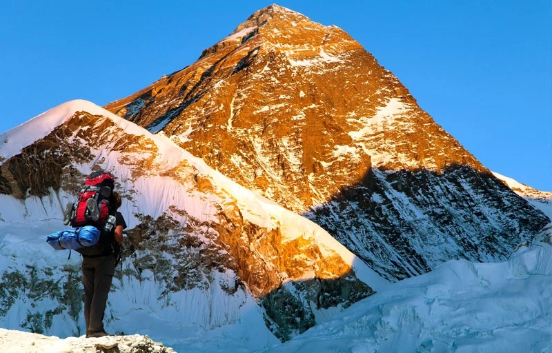
Chat with our Travel Designer Shiba
Need assistance? Our expert agent is here to help! Please fill out the form below to initiate a chat and get your queries resolved quickly.